7
Marine tenure in the Wellesley Islands region, Gulf of Carpentaria
This paper presents ethnographic material concerning four Aboriginal groups in a region of the southern Gulf of Carpentaria, namely the Lardil, Yangkaal, Ganggalida and Kaiadilt. At least for some decades now people have used these language names as ‘tribal’ or group identifying labels.1 The languages are closely related, and on the basis of linguistic analysis constitute a ‘Tangkic’ sub-group, the latter term deriving from the common word, tangka, meaning ‘person’ (Evans 1995: 9). The homelands and seas of these language groups are in the vicinity of the Wellesley Islands and adjacent mainland coast (Figure 7:1).
Indigenous classification of coastal environments
All these groups designate the marine environment as distinctive in its difference from inland areas. The Lardil people of Mornington Island (the largest of the North Wellesley group) classify their land and seas into two categories, ‘inside country’ and ‘outside country’ (Memmott 1983:34). The ‘inside country’ consists of what we might term the interior land systems, constituted by tussock grasslands, open low eucalypt woodlands and scrub lands. This landscape is distinct from the geologically much more recent coastal land systems which are known among
182Lardil people as ‘outside country’. The coastal areas are made up of tidal flats, sand-based cheniers and ridges, and interspersed cliffs, boulder beaches, off-shore wave-cut platforms and reefs. Figure 7:2 presents key properties of ‘inside’ and ‘outside’ country on Mornington Island, indicating among other things that most ‘story place locales’ are situated in the coastal ‘outside country’ and that this is also the landscape most modified by Lardil occupants.
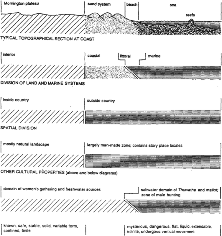
Figure 7:2 The Properties of inside and outside country on Mornington Island
183Similarly, according to Tindale’s research in the early 1960s (1977: 247–9), the culture of the Kaiadilt people of Bentinck Island (in the South Wellesleys) was focused very much upon the coastal parts of their island. Tindale suggests that most subsistence activities occurred in shore areas. He presents a map drawn by a young Kaiadilt man which places the sea (mala) in the centre of this man’s conceptual representation of his country, such that the perimeter of Kaiadilt territory is the coastline enclosing the sea (Figure 7:3). This is a powerful representation of the centrality of the sea in Kaiadilt perceptions of their territory.
In the case of the coastal Ganggalida people on the mainland, Trigger (1987: 72–4) has described how the traditional indigenous view is that the ‘land’ or ‘mainland’ begins at the inland limit of the saltpan, which also marks the dimensions of what is generally known as ‘saltwater country’. Figure 7:4 shows this limit, designating a coastal strip of ‘saltwater country’ extending southwards for distances varying between three and ten kilometres from the beach. Sand ridges are labelled ‘islands’ (murndamurra), the same term used for offshore islands (see also Figure 7:5). Thus, the coastal strip is regarded as environmentally and culturally distinctive from further inland, and as the domain of ‘saltwater people’. Throughout the islands and the coastal mainland there is a strong prohibition against mixing the material and spiritual properties of ‘land’ or ‘inside’ country with those of the saltwater domain; all language groups share the belief that illness and death can follow from mixing saltwater and land-based foods and the ‘fat’ or internal essence of land animals must be washed from the body before having contact with the sea (Evans 1995: 17–18; Memmott 1982). 184

Figure 7:3 Drawing by Kaiadilt man showing his concept of his country. Below is a comparative sketch map of Bentinck Island (after Tindale 1977:248)
Customary use of coast and seas
Throughout the Wellesley Islands, coastal places are used for hunting and collecting sea foods, which continue during the 1990s to contribute substantially to the local diet; resources obtained include turtle, dugong, fish, oysters, shellfish and crabs. Many rock wall fish traps (Lardil: derndernyn; Kaiadilt: ngurruwarra) have been constructed in 185parts of the littoral zone on the islands, whilst other rock or reef traps lie totally within the sea. It is generally believed that these traps were built by mythic ancestors. The North Wellesley
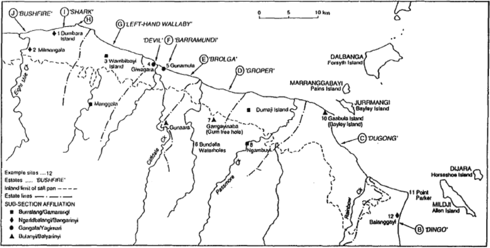
Figure 7:4 Coastal mainland Ganggalida country
Islanders believe their traps were shaped by the first Lardil people Maarnbil, Jirnjirn and Diwaldiwal who brought culture and language to Mornington Island (Memmott 1979: 205–9). Evans (1995: 16) reports the Kaiadilt view that the original construction of the many traps in the South Wellesleys is attributed to Bujuku (Black Crane) and Kaarrku (Seagull), but that older people also recall the contribution of human labour to building and maintaining fish traps. In the vicinity of Bayley Point and Point Parker on the mainland coast, the rocks comprising fish traps are similarly believed to be the flesh of the Bijarrba (Dugong) Dreaming ancestor. Senior Ganggalida people in the early 1980s, when asked, acknowledged human agency in their accounts about the historical construction of the traps; however, the mythic association with the rocks from which the traps were built, conflates this ancestral human agency with Dugong Dreaming itself. 186
Figure 7:5: Schematic Representation of Ganggalida Classification of Environmental Zones in the Mainland Coastal Area
| malara | mirlaja/ mala/lilu |
ngarnda | dumuwa | gabara | gin.gara |
‘sea’ |
go back/ sea/north |
‘beach’ |
[multiple ridges] |
‘saltpan’ |
‘flat country’ |
| [intertidal zone] |
‘sand ridge’ | [on other side of saltpan] | |||
| area containing murndamurra, ‘islands’ |
|||||
| ‘saltwater country’ | ‘mainland’ ‘land’ wambalda | ||||
Across the region, we have estimated a total of some 334 individual traps (located at 108 sites) on the islands and along the mainland coast.2 In general, most of the smaller islands have a relatively dense distribution of traps and sites. Bentinck Island in Kaiadilt country is enormously rich in this respect. Whereas on the Lardil people’s Mornington Island, our calculation is one site containing traps for roughly every 20 km of coastline, on Bentinck Island we have an average of one site every 0.9 km and a figure of one trap per 0.4 km. While participating in the recording of fish traps on Sweers Island in 1983, a senior Kaiadilt man casually listed six fish species, four kinds of shark and two types of stingray that were easily available for capture when routinely caught behind the trap walls with the receding tide. Clearly, there were many further species which could have been elicited; Evans (1995:17) notes for the Kaiadilt that ‘most food came from the sea and estuaries’.
187On the Wellesley Islands, people have continued to manufacture and in many cases use customary repertoires of artefacts for sea hunting and fishing (e.g. pronged fishing spears and spear throwers). Traditional technology has been supplemented with commodities from the wider Australian society including dinghies, outboard motors, steel spear prongs and nylon (for fishing lines and nets).
Since the establishment of a mission in 1914 in the southwest corner of Mornington Island the Lardil population has become gradually settled into residence at a single location. Nevertheless, from the 1970s a number of outstations have been developed and some families now live intermittently in decentralized camps and settlements in their homelands. In any case, hunting, fishing and gathering practices have continued throughout this century as activities especially focused upon the coast and adjacent waters. An important customary use of the seas was (and remains) that of travelling around and between the islands, to and from the mainland, and along the mainland coast. In the early contact period, rafts (Ganggalida: walbuwa; Lardil: walba; Kaiadilt: walbu) were used as an apparently longstanding traditional form of watercraft. Canoes (both sewn bark and dugouts) were also used throughout this century and probably earlier (see Trigger 1987: 80–1).3 Powered boats have now replaced rafts and canoes.
The continuity in marine travel practices should not be characterised as only focused on obtaining food but as also encompassing social and ritual interaction among different groups and between people and their country. This form of ongoing interaction would appear continuous from pre-contact times, especially within the domains of the different language groups, but also between the coastal mainland and
188the North Wellesley Islands; the latter travel was facilitated by a chain of islands, shallow waters and sandbanks exposed at low tides.
The Kaiadilt people were traditionally much more isolated by an expanse of difficult to traverse waters of some 13 km at its narrowest point. Tindale’s (1962a; 1962b; 1977) general suggestions about the extreme isolation of the Kaiadilt should be qualified by the facts of similarities between aspects of their traditional society and various mainland cultural forms (Trigger 1987). In the context of our research, there have been occasions during the past two decades when Kaiadilt persons have suggested that in the past there was intermittent interaction with mainlanders. Nevertheless, the results of intensive linguistic analysis lead Evans to suggest (1995:26) that (having migrated to the South Wellesleys from the mainland between 500 and 1000 years ago) ‘whatever contacts there were, that did not end in death or exile, must have been separated by decades of isolation’ (1995:17); he also mentions (1995:18) that nothing was obtained by the Bentinck Islanders via trade in times prior to European colonisation.
Throughout the past 50 years, Kaiadilt people have lived in close contact with the Lardil at the main residential township on Mornington Island, just as Ganggalida people have lived mainly at Doomadgee some considerable distance away from the coast. However, during the last couple of decades, there has been an increasing presence of people on both Bentinck Island and in mainland coastal Ganggalida country. Both these outstation movements (from Mornington Island in the case of the Kaiadilt, and from Doomadgee on the part of the Ganggalida) have been driven by a keen interest in maintaining broad cultural links with ancestral lands and seas. Kaiadilt people have had to re-establish their presence in the South Wellesleys after they were moved to Mornington Island Mission in 1947–8 (Tindale 1962a: 260); and Ganggalida people similarly began returning to their coastal domain from the late 1970s after being congregated some 100 km inland at Doomadgee Mission from the 1930s (Trigger 1992). 189
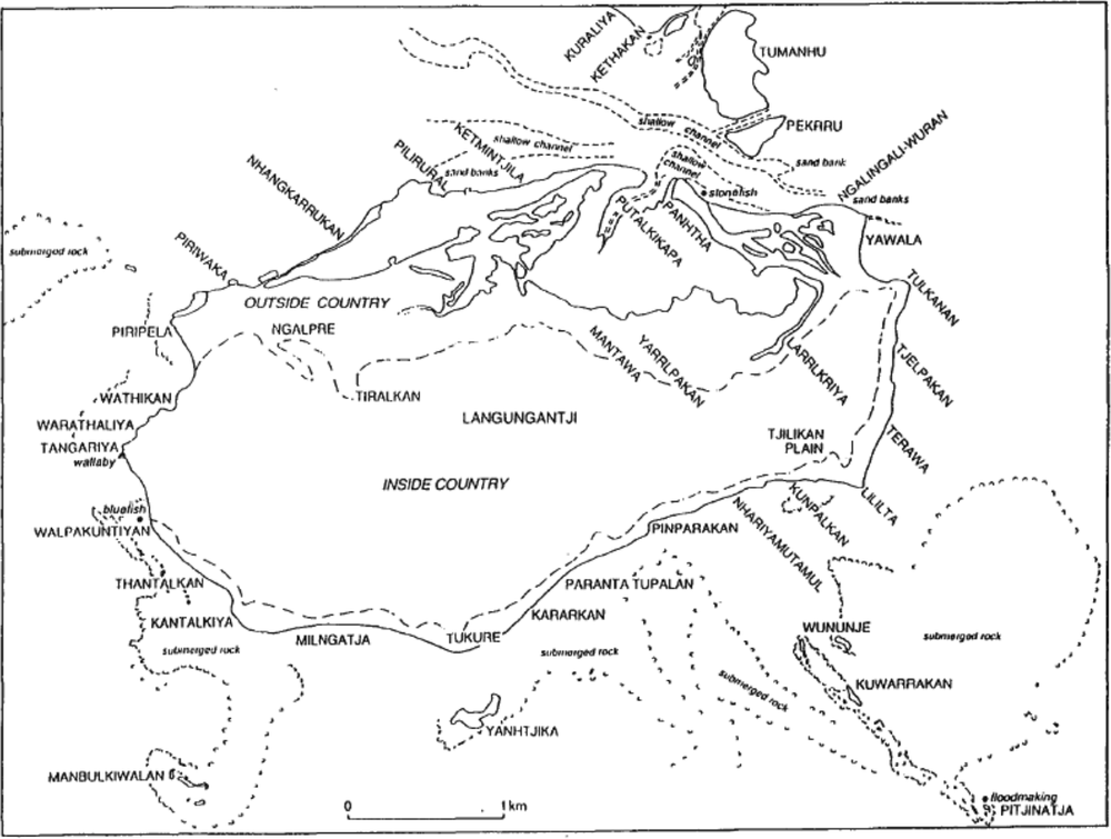
Figure 7:6 Lardil geography of Langungatji, Sunday Island
Widespread mapping throughout the Wellesley Islands and on the mainland has demonstrated that there is an intensity of indigenous geographic knowledge focused on the coastal land systems. There is typically a concentration of place names in these areas; indeed, it would seem that few parts of the coastal land systems were unnamed. In comparison, the interior areas of the islands contain few place names (see Memmott 1983: 51; Tindale 1962a: 276).
As well as designating various features along the shore, certain coastal place names are also used to identify adjacent offshore sea areas. In some cases, prominent features in the sea such as reefs, rocks, oyster banks, sandbars, or sand spits may have a specific name, especially if such a place is of sacred significance; e.g. Bijinaji, the floodmaking place in an underwater reef off Langunganji (Sydney Island, in the North Wellesleys) or Bangarnayirrb (Locust) Reef to the southeast of 190Ringurrng (Sweers Island, in the South Wellesleys). To give an idea of the intensity of coastal place naming, there are over 35 names recorded around the perimeter of Sweers Island in Kaiadilt country (an island of approximately 8.6 km x 2 km); similarly, in the case of Sydney Island in Lardil territory (5 km x 2.6km), there are over 30 place names around its perimeter (Figure 7:6). This gives an average of about one named place for every 350–500 metres of coastline. Tindale’s map of Bentinck Island (1962a) similarly presents a densely named coastal strip of country (and see Figure 7:4 for coastal Ganggalida country on the mainland, though this Figure shows only a small proportion of the named sites).
The intensity of coastal naming reflects the tendency for people to have traditionally spent much of their time living on the coast. Among the Lardil, most camps were located on the sand-based coastal systems and people maintained an orientation to the sea. A primary advantage of living in this location is ease of access to food resources. Such residential areas are within daily range of most of the land and marine systems, ensuring a great variety of habitats for many animals and plants, and an abundance of resources for artefacts and shelter manufacture. Furthermore, there were specialised locations on the coast such as turtle and dugong hunting camps (Memmott 1983:52).
Among Lardil and Kaiadilt people, there is a large body of customary knowledge concerning the marine environment, its plants and animals, the weather, tides and the behaviour of the seas. There is a detailed classification of the seasonal cycle, and extensive knowledge of the nature of offshore winds, the movements of fish schools, the times of the fattening offish and the reproduction of sea animals. As well as various techniques used to catch sea resources there are traditional practices associated with the consumption of certain species. While these practices have been maintained much more among those residing on the islands (including some people who would identify as mainlanders) coastal Ganggalida traditions mirrored the Lardil and Kaiadilt cultures in respect of this knowledge. For example, butchering of dugong was a rule-governed exercise right throughout the region, 191with different parts of the animal ideally being distributed to people of different status.4
Social and territorial organisation
Coastal clan estates appear to be a fundamental territorial unit of the four language groups discussed in this paper. In both the Lardil and Ganggalida cases, the dimensions of estates are defined by boundaries at roughly right angles to the shore line. While quite fixed by geographic markers on the coast, these estates may extend somewhat indefinitely out to sea or into the interior land systems. The boundaries of the coastal estates would appear to be subject to fission and fusion over time due to demographic changes, disputes, political activity and so on.
The culture of the Lardil exhibits a strong patrilineal ideology whereby coastal lands and seas are held by patricians and ownership rights are transmitted from male ancestors. People can also assert rights over country through connections to grandparents other than one’s father’s father; however, this would seem to have been practised more commonly among the Kaiadilt and Ganggalida peoples. Lardil individuals, as with the other language groups, also claim rights and interests in their birth-place, and flexible processes of succession most likely operated widely, according to demographic changes and political processes.
Lardil estate groups would commonly designate a senior person (usually a man) as a type of leader, somebody who was particularly responsible for decisions about use and management of bush resources, including important offshore foods such as dugongs and turtles. Such a person was referred to as dulmada in the Lardil language. Tindale
192(1962:273) has reported for the Kaiadilt that ‘the eldest living male’ of each patriclan estate-owning group is known as dolnorodangka (dolnoro being the term for the estate itself and dangka simply the word for man). Evans (1995:19) corroborates these data with the comment that each clan estate belonged to ‘a patrilineal clan headed by a dulmarra dangkaa (‘land-having man’), whose permission was required before hunting or fishing on his land’. Similarly, our understanding of the traditional Ganggalida terminology is that the sequence of patrician estates along the mainland coast were known as dulmarra (now more commonly termed ‘countries’ in English) and that a senior influential male member of the owning patriclan could be termed dulmarra dangka.
One aspect of the ideal role of the Lardil dulmada or estate boss, in the area of environmental management, is a rule concerning the hunting of dugong and turtle in marine estates. A hunter venturing into another clan’s marine estate should provide the local dulmada with certain cuts of meats from any dugong or turtle which is caught in that estate. While this rule is still given regular verbal expression today at Mornington Island, the practice of actually distributing meat in this fashion was disrupted from the 1920s and 1930s, when the entire regional population of Mornington Island gradually moved to live in the mission village. For since that time most people have in fact hunted close to the mission township and have not followed the prescriptive rule about meat distribution. Yet with the advent of the outstation movement over the last ten years, together with land rights and other forms of cultural resurgence, there has been some repopulation of the coastline around the island by small residential groups; and with this phenomenon has come both a degree of increased coastal surveillance by those occupying estate shores and a revitalization of the rule systems governing the management and sharing of local resources.
Such proprietorship over estate resources is also evident in the Kaiadilt case. During an inspection of fish traps on Sweers Island in 1983, a senior man explained how the dulmarra dangka would traditionally camp close to certain fish traps, to be on guard against wungiji dangka, ‘stealing man’, that is to say other Kaiadilt persons who might 193try to sneak into an estate to steal fish and other foods from the traps. Evans (1995: 19) mentions that this role of influential clan leader would be ‘passed to a brother or son by a sort of verbal deathbed will’ upon the death of the Kaiadilt dulmarra dangka.
Religious properties of coast and seas
Throughout the study area there are ‘story’ or ‘Dreaming’ places (known for example among Kaiadilt people as jungarrba dulka, ‘big [i.e. important] place’, see Evans 1995: 22), many of which constitute classical increase centres. Ritual actions performed by Aboriginal people at such a place are believed to activate the reproduction or fertility process of the totemic entity there. Some of these places are said to maintain particular plant or animal species, whilst others give rise to meteorological phenomena; for example there are story places for dugong, shark and fish species and for making tidal floods, cyclones and strong winds.
On the islands, almost all story places are located in the coastal land systems, either on the coast itself or offshore in the sea. For example, a site known as Ngawilan comprises three rocks rising from the sea near the eastern end of Mornington Island, which the Lardil believe to be the bodies of their ancestors, the first humans who came into their country. It is believed to be dangerous for outsiders to interfere with story places, which is why there is a perceived need to protect and manage these areas and exclude unhosted outsiders.
Totemic ‘energies’ are transmitted from story places to humans who are born (or in some cases, spiritually conceived) near a story place, or who preside over and regularly occupy the locale (e.g. the dulmada in the case of the Lardil). These people then possess a close identity with their story place and its occupants. Evans (1995: 20) points out for the Kaiadilt that:
Children are believed to show physical or temperamental resemblances to their conception totems—for example, a ‘dugong’ child may have a squashed ear like that of a dugong, or 194a ‘rainbow’ child may have a powerful temper like that of the rainbow serpent thuwathu.
Thus, the totemic entities provide personal subjective links into an invisible but co-existing spiritual world, a realm of non-human spiritual forces which thereby influences profoundly everyday life experience. The right of social identity with elements of this spiritual realm is linked inextricably to rights in coastal lands and seas. Many individuals have totems or Dreamings that are from the saltwater domain. For example, the leader of the Kaiadilt homeland movement in the 1960s and 70s was Darwin Moodoonathi, known as Ngarrawurna or ‘Bluefish’. This is one of the eight main totems among Kaiadilt people, the others all similarly belonging within saltwater country and seas: bijarrba (dugong), thuwathu (rainbow), dibidibi (rock cod), kulkiji (shark), thandamanda (water spout), rukuthi (casuarina tree) and walbu (raft) (Evans 1995: 20). On Mornington Island it has been common to hear individuals referred to as ‘Rock Cod’ or ‘Shark’ or ‘Barramundi’, i.e. using names referring to the Dreaming with which they are associated closely.
For the Lardil there is a close relationship between story places and sacred knowledge. By frequenting a story place locale, individuals may receive gifts of knowledge via dreams. Such knowledge appears to be qualitatively different for each particular story place and we might thus describe a ‘territorialisation’ of Lardil cosmology. The knowledge obtained from the realm of Dreamings is often in the form of songs with accompanying dances, each of which encompasses one or more associated designs used in performance. For example, there is a chest design for the splash of saltwater on the beach.
Much religious knowledge recounts the creation of aspects of the environment by mythic ancestral beings. An example from coastal Ganggalida country on the mainland is Bijarrba (Dugong) Dreaming, which emerged from a fresh water hole some 17 km inland, to then proceed down a watercourse to the sea; on the way, Dugong was speared, its flesh turning into rocks as a consequence of being treated haphazardly by people. After proceeding through the saltwater to the off-shore 195islands this Dreaming went westwards through the sea towards Yanyuwa country. From the Lardil perspective, at the time of these mythic ancestors, it is believed that much of the sea was in fact land, and Gununa (Mornington Island) was part of a large peninsula. Most of the coastline is believed to have been created or fashioned by ancestral Dreamings and in some areas they submerged parts of the land beneath the sea. Thus, many of the travel paths and places created on land by these mythic forces are today part of the sea and sea bed.
Examples include certain sacred histories which recount how various ancestral Dreamings cut through the land to make channels for the sea in the North Wellesleys—between Forsyth and Francis islands, Forsyth and Andrew islands and Denham and Mornington islands. Other histories tell how islands were ‘cut out’—for example, the South Wellesley Islands of Mirrimanki (Albinia), Durathi (Margaret), Kandingarrbayi (Bessie), Nathayiwinda (Douglas) and Baltayi (Fowler) islands. It is worth noting that such ‘creation’ of the islands is consistent with the process of eustatic sea level changes of the post-glacial Pleistocene and the Holocene, some 6500 years ago, when the Wellesley Islands came into existence according to scientific accounts of the geological history of this area (Memmott 1979: Ch.1).
Indigenous ‘law’ recounts the travel of various ancestral beings through the sea. Ganggalida oral traditions tell of the route taken by Shark Dreaming westwards from ‘Dumbarra country’ (in Estate I as shown on Figure 7:4), eventually arriving at a site known as Manangurra in Yanyuwa country (see Bradley 1988). During such travels the Dreamings performed specific activities at particular places. According to the Lardil perspective, Shark Dreaming (which is associated with the origin of Cycad trees throughout the region) travelled along the entire northwest coast of Mornington Island planting the seeds of this species of tree. Evidence of this mythic activity are the groves of Cycads which now grow at specific places. Similarly, on the southeast coast of Mornington Island a party of largely marine mythic animals and birds travelled along the coast, stopping at various rocky islets, reefs, and spits 196and tidal flats. A further example is Dingo Dreaming whose travel route connects the coastal mainland with both the North Wellesley Islands and distant inland areas.
Such travel lines can be encoded as a series of public and secret songs (known as kujiga) that are sung during male initiation ceremonies. While these ceremonies stopped being performed from around the 1930s on Mornington Island (and have not been performed in coastal Ganggalida country for a long time), they were revived on Mornington during the 1970s and now constitute a regular activity that is important in the reproduction of indigenous identity. Initiation ceremonies involving circumcision are part of the cultural traditions of all language group in the region (e.g. Evans 1995: 22–3).
Among Lardil people, there is a general body of sacred knowledge of particular significance as it deals with the mythic history of Thuwathu, the Rainbow Serpent, and explains its potent presence and powers throughout the seas today. Rainbow is believed to continue to exert strong influence on the well-being and health of humans. Rainbow can inflict a sickness known as markirii (Memmott 1982). The presence of this major Dreaming extends into the littoral domain, including those more elevated parts inundated only during very high tides. Some groups believe that cyclones, waterspouts and rainbows are manifestations of Thuwathu.
Throughout the region the spiritual features of ‘saltwater country’ are generally entwined closely with traditional resource gathering activities in coastal domains. The socioeconomic importance of the sea and coastal land systems, especially on the islands, complements the intensive bodies of religious knowledge that also pertain to ‘saltwater country’. This aspect of indigenous cultures in this area can be referred to locally as ‘Sea Law’ or ‘Saltwater Law’. 197
Issues of Native title
The Wellesley groups have commenced a joint native title application over their sea country.5 In part, this action has been precipitated by the threat during recent decades to the customary control of their sea from non-indigenous fishermen. The latter persons at times harvest fish, dugongs, turtles and crabs, in a way that causes considerable distress amongst traditional owners, particularly when they use dynamite and/or netting practices that kill too many animals and are regarded locally as threatening the survival of certain species. Also of concern has been a proposal to build a slurry pipeline which would extend from an inland mine to a port either on the mainland coast or on an off-shore island.6
In making application for a marine native title determination, the Wellesley peoples have encountered a conceptual challenge in nominating how far to claim out to sea, given that no fixed boundary lines exist under customary marine tenure. A fairly common view amongst the claimants is that all seas within visual range of the shore are most certainly part of their sea country; this range may be about 20km but varies with the height of the viewer, the elevation of their observation point, tides, wave action, weather and general conditions for visibility. Visibility of the land from the sea was extremely important for
198traditional marine navigation. Conversely, surveillance of the sea from the land is a constant preoccupation for those with a marine economy and cosmology.
While traditional customary use of the seas prior to European colonisation was limited by the available watercraft technologies, and while the South Wellesley islanders in particular faced a substantial degree of isolation, there was constant use of the seas in this area of the southern Gulf of Carpentaria. Furthermore, tenure over the sea should not be conceived solely in terms of waters that were available for physical use.
It should be clear from the results of intensive ethnographic research presented in this paper that expansive areas of the sea are regarded as owned because of their intellectually recognised properties as well as their economic significance. With the adoption of motor driven watercraft local Aboriginal people can now more safely use broader expanses of their sea country for resource-obtaining and other activities. This change wrought through processes of colonisation has involved a gradually increasing use of seas further out from coastal camps. However, we would argue that this represents an increased use of seas that were always regarded as customarily owned. A final comment on this matter is apposite.
Because of the relationship between coastal/offshore story places and meteorological phenomena, many cloud, tide and wind events which occur within visual range out to sea, are believed to be causally linked to the activities of humans at story places. The visual range of clouds in the sky, of course, extends beyond the limit of the horizon, but just how far is still under investigation. It has been calculated that a Morning Glory cloud travelling from the east at an elevation of about 1000m can be seen on a very clear day at a distance of about 112 km from Sweers Island.7 Rising cumulo-nimbus clouds in summer storms8
199can probably be seen at significantly longer distances. Yet Aboriginal claimants will maintain that such phenomena can be controlled or influenced from nearby places in the seas surrounding the Wellesley Islands. There is thus a notion that Saltwater Law, as practised through customary behaviour, extends out into this wider territorial marine domain. In this sense, the notion of native title rights and interests in sea country should be understood as potentially extending much further than solely over the waters used customarily for traditional hunting and fishing.
References
Bradley, J. 1988. Yanyuwa country: the Yanyuwa people of Borroloola tell the history of their land. Richmond: Greenhouse Publications.
1991. ‘Li-maramaranja’: Yanyuwa hunters of marine animals in the Sir Edward Pellew Group, Northern Territory. Records of the South Australian Museum 25 (1): 91–110.
Evans, N. 1995. A grammar of Kayardild, with historical-comparative notes on Tangkic. Berlin: Mouton de Gruyter.
Keen, S. 1983. ‘Yukulta’. In Handbook of Australian languages v.3 (ed) R. Dixon. Canberra: Australian National University Press. Pp. 191–304.
Memmott, P. 1979. Lardil properties of place. Unpublished PhD thesis. Brisbane: University of Queensland.
1982. Rainbows, story places, and Malkri sickness in the north Wellesley Islands. Oceania 53:163–182.
1983. Social structure and use of space amongst the Lardil. In Aborigines, land and land rights (eds) N. Peterson and M. Langton. Canberra: Australian Institute of Aboriginal Studies. Pp. 33–65.
1986. Lardil ethnography: the Aboriginal geography of place in the north Wellesley Islands. Man-Environment Systems 16(5 and 6): 218–226. 200
Neal, A., Butterworth, I. and Murray, K. 1977. The Morning Glory. Canberra: Department of Science, Bureau of Meteorology. Technical Report 23.
Robins, R., Stock, E. and Trigger, D. 1997. Saltwater country, saltwater people: geomorphological, anthropological and archaeological investigations of coastal lands in the Gulf Country of Queensland. Memoirs of the Queensland Museum (Cultural Heritage Series) New Series 1:1.
Tindale, N. 1962a. Geographic knowledge of the Kaiadilt People of Bentinck Island, Queensland. Records of the South Australian Museum 14(2):259–296.
1962b. Some population changes among the Kaiadilt people of Bentinck Island, Queensland. Records of the South Australian Museum 14(2):297–319.
1977. Further report on the Kaiadilt people of Bentinck Island, Gulf of Carpentaria, Queensland. In Sunda and Sahul: prehistoric studies in Southeast Asia, Melanesia and Australia, (eds) J. Allen, J. Golson and R. Jones. London: Academic Press. Pp.247–273.
Trigger, D. 1987. Inland coast and islands: traditional Aboriginal society and material culture in a region of the southern Gulf of Carpentaria. Records of the South Australian Museum 21(2): 69–84.
1992. Whitefella comin’: Aboriginal responses to colonialism in northern Australia. Cambridge: Cambridge University Press.
1997. Reflections on Century Mine: preliminary thoughts on the politics of Indigenous responses. In Fighting over country: anthropological perspectives (eds) D. Smith and J. Finlayson. Canberra: Centre for Aboriginal Economic Policy Research, Australian National University. Pp. 110–128.
1 The name ‘Ganggalida’ is also known in published literature as ‘Yukulta’. However, during the past two decades, at least, it is the former term which has been used for both the language and the people or ‘tribe’ identifying with it. Keen (1983: 192) points out that ‘ganggalida’ literally means ‘word’ or ‘language’.
2 Since the early 1980s, we have carried out collaborative research on the fish traps with Richard Robins of the Queensland Museum, comprising of visits to trap locations, counts from a low-flying aircraft and examination of aerial photographs. Extensive analysis of these data is proceeding at the Queensland Museum.
3 In earlier times, some missionaries on Mornington Island wilfully destroyed canoes. This practice was aimed at discouraging the butchering of dugong and turtle in the vicinity of the Mission in order to minimize shark attacks on the dormitory children who were required to bathe regularly in the sea. Despite such setbacks, Lardil people can be said to have adapted and maintained their traditional hunting and fishing activities throughout the mission era (1914—1976).
4 Bradley (1991) provides a detailed depiction of such knowledge among the Yanyuwa people whose territory is in the vicinity of the Sir Edward Pellew Islands, some 250 km to the west. Mainland Ganggalida people have had considerable historical contact with groups and individuals from Yanyuwa country, this interaction seemingly having intensified since European colonisation.
5 A separate Magistrates Court case has involved a particular Ganggalida man defending a charge of taking a protected animal on the grounds of his native title rights to do so according to Aboriginal law. As well as the defendant’s evidence, the Magistrate accepted the results of ethnographic research and archaeological findings demonstrating Aboriginal occupation of a coastal Ganggalida estate (Eaton vs Yanner, No. 1692 of 1995, Mt Isa Magistrates Court).
6 The slurry pipeline from Century Mine was finally routed away from the immediate Wellesley Islands area to Karumba some considerable distance to the east. However, concerns about initial plans for it to run into coastal Ganggalida country and then out to Sweers Island caused much tension and concern among traditional owners of these areas (see Trigger 1997).
7 These figures have been provided to the Carpentaria Land Council by Ms Cathy Robinson, Department of Geography and Environmental Science, Monash University, December 1995. Ms Robinson was requested to research this matter. For meteorological analysis of the ‘Morning Glory’ cloud, see Neal et al (1977).
8 Called thaldija or ‘tower-up’ clouds in Kaiadilt (Evans 1995: 769).