13
The Sea of Waubin: the Kaurareg and their marine environment
In attempting to reconstruct the social institutions surrounding ownership and control of the marine environment of the Kaurareg,1 it should be born in mind that the Kaurareg have experienced an extreme degree of social and cultural dislocation since the arrival of Europeans in the Torres Strait in the 1870s. As a result of the massacre of the crew of the Sperwer at Wednesday Spit between Wednesday Island and Hammond Island in 1869 (Sharp 1992:30), the Kaurareg on Prince of Wales Island (Muralag) were in turn massacred, almost to the point of extinction (Sharp 1992:70; Singe 1979:169). It was later discovered that the killing of the Sperwer’s crew was carried out not by Kaurareg but by the Kulkalgal of Naghi island (Sharp 1992:72; Singe 1979:168). But by this time only a handful of the Muralag population were left. The survivors were moved to Hammond Island (Kiriri). Kiriri was subsequently chosen as the site of a Roman Catholic Mission and in 1922 the Government moved the
352Kaurareg at gun point to Moa island.2 The Kaurareg lived on Moa island until 1947 when one of the Kaurareg elders, Elikiam Tom, attempted to move back to his country on Kiriri. Upon his return to Kiriri, however, Elikiam Tom was told by the Catholic Father in charge of the Catholic Mission on Kiriri that he could only stay on the island on the condition that he converted to Catholicism. Not wishing to do this, Elikiam Tom moved to Horn Island (Narupai) where he was soon joined by other Kaurareg elders from Moa, who, on their own initiative, started building a ‘model village’ at the site now known as Wasaga village. In 1950 the Government decided to move the Kaurareg away from Narupai for the same reasons ‘that had led to the forced removal of the Kaurareg from Hammond Island’ in 1922 (Sharp 1992:116). The Department of Native Affairs proposed to resettle the Kaurareg at Red Island Point on the mainland but this time the Kaurareg stood their ground and they remained on Narupai (Horn Island) and they continued to use their traditional land and sea country in the region.
Customary marine tenure
CMT is taken to refer not only to the ownership or control of areas of the sea, but also (and perhaps more importantly) to the ownership or control of marine species: an important issue in sea tenure is that the sea is not the resource itself but merely the medium in which the resource moves (Southon 1989:367).
The traditional use and control by the Kaurareg of their marine environment can only be understood in the context of their beliefs about ancestral spirits and the supernatural order. Central to Kaurareg marine tenure is the mythological figure Waubin, whose exploits provide the charter for Kaurareg tenure of both land and sea. Waubin was a warrior
353and a giant who came from mainland Australia to the island of Muralag which was already inhabited by a number of other mythological figures, also warriors. Waubin either killed these individuals or chased them out to sea, acquiring their wives in the process. Waubin was turned into stone and his metamorphosed body lies off the northeast end of Hammond Island as a rock named Waubin (Hammond Rock). There, as an outpost of Hammond Island, Waubin protects the islands to the south from intruders. He sends a strong current through the Prince of Wales channel which is said to discourage outsiders from venturing further south into the Kaurareg area. This deep channel, which runs along the north side of Hammond Island, is known as Waubinin Malu, or ‘The Sea of Waubin’.
Though Waubinin Malu refers specifically to this channel on the north side of Hammond Island, Kaurareg people also use the term in a more general sense to refer to the whole Kaurareg sea territory. During his battle with the warriors on Muralag, Waubin encountered Badhanai, a warrior of very small stature, who darted between Waubin’s legs and sliced off his right leg with the bamboo knife upi (Sharp 1992:105). The blood from Waubin’s leg was carried by the currents throughout the waters surrounding the Prince of Wales group of islands. Wherever the blood from Waubin’s leg was taken became Waubin’s territory; thus it is that the whole sea enclosing the Kaurareg islands is called Waubin in Malu.
Though there is ambiguity about the extent of the traditional Kaurareg sea territory (see Figure 13:1), some points are clear. In the north the Kaurareg sea extended as far as the channel between Warar (Hawkesbury Island) and Dollar Reef (which belonged to the people of Moa). On the south side of Hawkesbury Island is a rock which represents Pithulai, a warrior who fled Muralag Island, driven by the ever-jealous Waubin. On the west side of the island lies another rock which represents Ibibin, another warrior who fled Muralag for the same reason. These two mythological figures are said to mark the northern extent of the Kaurareg sea territory: 354
He (Waubin) sent them (Pithulai and Ibibin) out to the island, they in that place, that’s identification for Muralag … that Pithulai and Ibibin (Billy Wasaga, Kaurareg tribal elder).
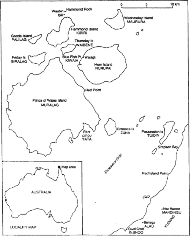
Fiure 13:1 Muralag and adjacent islands
355In the west, Kaurareg sea extended as far as Booby Island where there is a rock that represents Ngiyangu, another warrior who was chased off Muralag by Waubin. Billy Wasaga described the role of Ngiyangu as a boundary marker:
That what he stand there for, stop there, that’s Kaurareg district, let the other people know that as a far as boundary, you know, for this way boundary.
The southern boundary of Waubinin Malu is less clear, perhaps reflecting the fact that Kaurareg traditionally had much better relations with their southern neighbours than with Islander peoples immediately to the north (Singe 1979:164). For example, informants state that the turtle hunting grounds on the islands south of Muralag, though they belonged to the Kaurareg, were shared with the Gudang people of the mainland.
Though Kaurareg conceived of their boundary as a number of significant sites rather than as a line, informants say that Kaurareg people always knew whether or not they were in their own sea territory or that of a neighbour. For example, people state that Kaurareg traditionally would not fish or hunt north of Hawkesbury Island, and would kill anyone from the north without traditional rights who fished or hunted south of Hawkesbury Island.
Within the Kaurareg sea there appear to have been no further spatial divisions governing ownership of the marine environment. Rather, the ‘Sea of Waubin’ was held in common by all the related clans inhabiting the Kaurareg islands. Each clan had a chief or mamus3 but there was also an overarching mamus for the whole Kaurareg people. By some accounts this chief mamus governed the use of the fishery. For example, he would use sorcery to call up dugong and then allocate a certain number of dugong to be taken by each community. Communities which took more than the quota assigned by the chief mamus were punished. There was a strong ethic of taking from the sea only what was required
356to satisfy immediate needs. Indeed, a principle of Kaurareg marine lore is that one can only fish or hunt successfully when one is hungry. There were strong sanctions, enforced both by the elders and by the clan leaders, against extravagant exploitation of species.
The use of magic to call up species was an important element in the Kaurareg management of their marine environment. This practice can be considered an aspect of marine tenure, since it involved the control of access to marine resources. As well as dugong, turtle were also called up by the use of sorcery. Amongst the people of Moa, who like the Muri Islanders were part of the Kaurareg, a rock in the shape of a turtle’s back was used to call up turtle during the mating season. It was said that within five minutes of the ritual being performed, turtles would start coming ashore at a nearby beach.4
The calling up of species is still an important feature of Kaurareg hunting and fishing. It is often said that only people who know how to ‘talk to the country’—whether on land (murrup) or sea (malu)—are able to hunt or fish successfully in a given locality.
Kaurareg people state that the waters within the Kaurareg sea territory were regarded as a common resource to be shared by all Kaurareg. However, the institution of gangar shows that on an informal level there was (and is) some kind of individual tenure of the sea. A gangar is a fishing spot where a particular individual regularly fishes. Some gangar are closely guarded secrets and are handed down to a man by his father, together with a spell or magic formula that ensures good fishing. A further example of marine tenure below the level of Waubinin Malu was the ownership of stone fish traps. There were at least two stone fishtraps in Kaurareg waters: one in the Bay of Siziri on the north side of Hammond Island and another at Thaniu buthu (butu, ‘beach’) on the south side of Hammond Island.
357
Traditional knowledge of the marine environment
One of the most important institutions in Island society was the initiation, or Kernge, whose function was the transmission of mythology and traditional knowledge about the marine environment from elders to young men. The main informant for this chapter, Billy Wasaga, did not become an initiand as the kernge had already ceased to operate by the time he was a young man.5 However, his father did go through kernge and passed on some of his knowledge to Billy. Billy also said on a number of occasions that his knowledge of the stars and tides and the behaviour of marine species is only a fraction of what it would have been, had his people not been removed from Hammond Island:
These people in this area, they studied water and tide, that’s what I tell you about kernge, they know which place to go to in which time, that’s why they study them two, for that sort of thing. They lived on the water! Their life, that was their food, in the water!
The elders taught the kerngeli, the young men, by instructing them to go out and catch certain species from certain places at certain times of the year. Informants say that the young men would always find what they had been told to catch at the specified location: such was the knowledge of the elders who taught them. However, they had to bring back the exart number or quantity of the species which the old men had specified, or face punishment. As Billy said:
.. they (the elders) send him (the kerngeli) out, they see that tide and after they tell him alright you go and get some fish, alright, and they tell him don’t spear any fish, only one fish they send him for spear that one, they don’t kill lot, just one kind, and if he can’t find that one…but he will find it, because
358they send him at the right time, the tide is there, the fish will come on top, they get it, … for the dugong same thing again, send him out at night, ‘You take one, not more than one’, they go out, get it, bring him home, they say ‘one’ or ‘Get more than one’, well, they get it, but they get the number, the figure, how much they bring him in, got to bring the same figure, not more not less, exactly what they said, its a training.
Tides and currents
Johannes and Macfarlane (1991:16) note that tides in the Torres Strait Islands are ‘complex, pronounced, unusual and unpredictable’. They go on to observe that ‘Numerous reefs, banks and islands accentuate the tides’ effects, generating swift, complex currents that strongly influence the Islanders’ choice of methods for fishing and for hunting dugong and turtle’. This fact of the marine environment is reflected in a well developed Kaurareg vocabulary for tides and currents.
Kaurareg people distinguish amongst at least six different kinds of tide: gath (very low), seisam (low), koei wur (high), silel badh (very high) and yabagar (highest). Yabagar occurs only during the northwest monsoon or Kuki. Between seisam and silel badh is another tide whose name people could not remember. Seisam is a particularly good tide for collecting crabs as the roots of the mangrove trees are left exposed for about a week.
Tides which flow with the wind and against the wind produce different surface conditions. When the tide is running in the same direction as the wind, it is known as kuulis, when it is flowing in the opposite direction to the wind, it is known as guuthath. The interval between tides when the water becomes temporarily still is known as kas.
An example of how the Kaurareg used detailed knowledge of the tides in the exploitation of the marine environment concerns the catching of turtles on Kathainab reef. From a hill on the south side of Hammond Island called Zangaitha (Bruce Point), Kaurareg elders had 359a clear view of Kathainab reef, the first of the three reefs lying on the north side of Hammond Island. Inside Kathainab reef is a lagoon called Dhudhun Li (lit. ‘Dhudhun’s basket’). A certain tide would take turtle into this lagoon and then leave them stranded there when it receded. From their vantage point at Zangaitha, Kaurareg elders would observe the tide and at the right moment would send young men in canoes around Hammond Island to Dhudhun Li, knowing that by the time they arrived the tide would be down and the turtles trapped.
A senior elder explained that tides are of general importance in the catching of turtle. When they find themselves in strong tides or currents, turtle always seek the security of reefs or islands to avoid being taken too far out to sea. Certain reefs and islands between Muralag and the mainland are known to be good places to find turtle when certain strong tides are running.
Knowledge of tides is also essential for catching fish. As is discussed below, Kaurareg have a repertoire of places known to be good for catching certain species of fish marked by gangar. But this knowledge is not sufficient in itself for each spot is associated with an optimal tide: it is knowing the combination of place and tide that determines success in fishing.
Off the northeast of Kiriri (Hammond Is.) lies a group of rocks called Ipili (‘the wives’, see Figure 13:1), which represent Waubin’s wives. Some distance further out to sea lies a single rock which is the metamorphosed body of Waubin. When the tide is flowing southeastwards past Hammond Island towards Horn Island, a current is generated which acts as a backwash, flowing from Ipili around the eastern side of Waubin. When the tide is running in the other direction (i.e.. flowing northwestwards from Horn Island to Hammond Island), the same phenomenon occurs in reverse; a current runs from Ipili around the western side of Waubin. This current which always flows out from Ipili to Waubin, is called Muibubu (‘inner current’). Its origin is grounded in mythology. Waubin placed his wives at Ipili and then he himself went and stood out to sea forming Hammond Rock. Waubin, known for his jealous guarding of his wives, so positioned himself that anyone 360wanting to see his wives would have to encounter him first. Thus it is, Kaurareg people explained, that whichever way the tide is flowing, a ‘back current’ will always take you back out from Ipili to Waubin.
As can be seen from the above account, currents are thought to be caused by ancestral spirits. In some cases, currents can be slowed down by making offerings to the spirits associated with them.
Just off the northeast corner of Muralag (Prince of Wales Island) is an oblong rock named Kiwain. In the narrow gap between Kiwain and Thursday Island the sea boils up, probably the result of the meeting of several different currents. Kaurareg say that in the days when heads were an important item in the trade between Torres Strait and New Guinea, the victims of Kaurareg headhunting raids were beheaded on this rock. Their bodies were thrown into the sea, thereby ‘feeding’ the current and slowing it down.
Somewhere between Hammond Island and Moa Island is an area of sea which Kaurareg people describe as being ‘boxed-in’ by currents on all four sides. Kaurareg people still placate the spirit of this potentially treacherous patch of sea by throwing bread into the water or by lighting a cigarette and throwing it into the sea.
The seasonality of resources
Kaurareg divide the year into two main seasons: Sager and Kuki. Sagerau thonar, the ‘time of the southeast winds’, lasts from the end of March through to November, while Kukiyau thonar, the ‘time of the northwest winds’, lasts from December to March.
During Kuki or ‘northwest time’ the Kaurareg traditionally concentrated on dugong and avoided eating most species of fish. A species of jellyfish appears during the northwest monsoon and is eaten by turtle and by many species of fish. Eating the flesh of these species causes the skin to swell up and become itchy. The herbivorous dugong which feeds exclusively on seagrass, are unaffected by the jellyfish. Some species of fish, especially those living in creeks and swamps, do not feed 361on jellyfish and are therefore targetted in December, January and early February. These are the file stingray (thukmul), two species of mullet (the silver mullet, maker, and the big-scaled mullet, muragudal), leatherjacket (karmui), grunter (zaram), bonefish (kube), garfish (zaber). During the northwest season Kaurareg would also gather and eat mangrove seed pods (biyu).
In the middle of the northwest season, in the month of January, two stars appear in the early morning. These stars represent the mythological figure Dhogai, a devil-woman who ‘gathers every tucker from the sea and puts him in one place’. The appearance of Dhogai signals that the jellyfish are gone and that it is safe again to eat fish. After these stars appear, shallow waters are said to be teeming with fish and other marine life. However, though the jellyfish are gone, the waters are dirty from March to April, making it difficult to spear fish.
Towards the end of February another group of stars, (zugubal), appears in a certain position in the southern sky, indicating that the southeast winds are imminent. This takes the form of a shark (baidam). When the shark stands on its tail, the Sager season is about to start. Sager lasts from April through to October and is said to be a time of plenty: all species of fish are ‘fat’, as are crabs, mussels and bailershells. The water is clear, and at the same time there is abundant ‘bush tucker’. Many plant species, whose shoots appeared in October of the previous year, are now ready to harvest. In particular, two species of yam, kuthai and sawur, are harvested in the months following April.
In August the southeast winds abate and the weather turns fine. In September the winds become northeasterly (naigai). This is known as the period of ‘hot sun’. From the end of August to the beginning of November is the turtle breeding season or soeulal, when mating pairs of turtle are found floating on the surface in ‘fast’. Soeulal is a good period for turtle hunting since the turtles are less alert than they normally are and therefore easier to catch. Furthermore, the females are considered particularly good eating at this time of the year as they have started to produce eggs. 362
In November the winds become squally again and a constellation of stars called Dagul (lit. ‘thunder’) drops towards the horizon in the southern sky. This constellation consists of five stars which take the form of a fishing spear. The falling of this constellation below the horizon is known as Dagul sisari (lit. ‘the coming down of the Fishing Spear’). Dagul sisare is associated with various other natural phenomena. Firstly, as soon as Dagul drops into the sea, the thunder and lightning of the wet season begin. It is said that as long as the ‘thunder stars’ are in the sky, there is no thunder or lightning. Secondly, the disappearance of Dagul below the horizon brings on the rains of the northwest monsoon: it is said that Dagul falls into the sea with a big splash, causing a downpour of rain on the islands. Thirdly, the disappearance of Dagul signals the end of the turtle breeding season; the ‘sliding’ of Dagul below the horizon is linked to the sliding of the male turtle off the female turtle’s back. This time is known as waru sisanthari (waru ‘turtle’, sisanthari ‘to slide’). Fourthly, as soon as Dagul drops into the sea, various species of fish—in particular the file stingray (thukmul), make for shallow water where they are easy to spear. Dagul is said to be like a person who chases the fish towards the creeks and mudflats.6
The transforming effect of Dagul is evident not only on sea but on land as well. Dagul is said to shake up the land, causing rapid growth in all plants, leading to the abundance of bush tucker, particularly wild yams, in the following season of Sager.
Specific locations for hunting and fishing
Kei Yelubbi and Meggi Yelubbi were nesting grounds for green turtle as were Dumaralag Island, Woody Island and Red Woody Island. The last two islands, in addition to being turtle hunting grounds, were also places where three species of bird eggs were gathered: kangan, sara and
363sialwal. Dugong were hunted in the mouth of Kuipidh creek on Horn Island. A reef on the northeast side of Horn Island called Taigwata was known as a place to hunt hawksbill turtle. On Tharilag and Zuna islands there were several known fishing spots. Between Horn Island and Thursday Island there is a reef called Thoerigani which is known as a good fishing site. On the south side of Horn Island is a place called Puwapun, a large rock with a reef around it, which was a main fishing place in former times. Between Yelubbi and Tuidin (Possession) Island are some rocks which is a place known for catching hawksbill turtle.
The contemporary fishing economy on Horn Island
Fishing amongst the Kaurareg of Horn Island can broadly be divided into two categories: small-scale handlining and spearing from the rocks, beaches and jetties of Horn Island, and the more intensive fishing, crayfishing, and hunting of turtle that is done from aluminium dinghies powered by outboard motors, of which there are about twenty on the island. There are five full-time Kaurareg fishermen on Horn Island. These men fish for crayfish on the islands of Muri (Mt. Adolphus) and Warar (Hawkesbury) and on the three reefs north of Hammond Island (Kathainab, Dadatiam and Giyai Moeza). There are a further nine men who are part-time fishermen.
In 1990 there was an attempt to start a trochus gathering enterprise on Muri Island. The project employed a number of young Kaurareg men from Horn Island and was part of the CDEP program. It foundered shortly after its inception and has not been revived.
For most Kaurareg people on Horn Island, fishing is a way of supplementing income derived from various forms of social security such as pensions and unemployment benefit. One informant explained that many households on Horn Island find their cash income is only sufficient to meet rent and non-food bills; by the second week of the pension 364period they have no money left for food and therefore they engage in subsistence fishing.
Beyond its purely economic significance, exploitation of the marine environment is closely bound up with Kaurareg social organization (Beckett 1994:5). One example of this is the role of dugong and turtle meat in Kaurareg feasts, held at ‘tombstone openings’, weddings and funerals. At a more fundamental level, the activities of fishing and marine-hunting are the basis of Kaurareg self-identity.
The Kaurareg fishing economy and the fisheries of the Torres Strait
The Kaurareg seas lie within two different fisheries management regimes. A small area in the north of the Kaurareg seas lies within the Protected Zone and is therefore under the jurisdiction of the Torres Strait Protected Zone Joint Authority (TSPZJA). The remaining area of Kaurareg seas (to the south) lies within Queensland jurisdiction and is thus under the management of the Queensland Fisheries Management Authority (QFMA). The main fisheries within the area of the TSPZJA are prawn, lobster, mackerel and live pearl shell, while the main fisheries in the area of the QFMA are trochus shell, beche-de-mer, and cultured pearls.
Figure 13:2 Indigenous involvement in each of the Torres Strait fisheries
| Share of catch% | ||
| Islander | Non-Islander | |
| TSPZJA Fisheries | ||
| Prawn | 0 | 100 |
| Lobster | 70 | 30 |
| Mackerel | 3 | 97 |
| Live pearl shell | 100 | 0 365 |
| QFMA Fisheries | ||
| Trochus shell | 100 | 0 |
| Beche-de-mer | 100 | 0 |
| Cultured pearls | 0 | 100 |
(Source: Altman, Arthur and Bek, 1994:11)
There are a number of characteristics regarding indigenous involvement in Torres Strait fisheries. Firstly, there is no indigenous involvement in prawn trawling. This can be attributed partly to the high capital costs of entering this fishery as well as high operating costs. Another important barrier to indigenous involvement in prawn trawling may be the conditions of employment: ‘…the demands of employment in the commercial prawn fishery do not make this fishery attractive for Islanders owing to the need to work long continuous shifts for several months at a time’ (Altman et al. 1994:12). Secondly, there is a high indigenous participation in the lobster fishery. This is attributable to the low capital costs of entering the fishery (the cost of an aluminium dinghy and outboard engine) and the extremely high profit margins (1994:13). Thirdly, the fisheries that have the highest incidence of indigenous involvement— trochus and pearl shell collection—are those in which Islanders have had long-standing involvement and expertise (1994:12). Overall indigenous participation in Torres Strait commercial fisheries is slight; the prawn fishery—which alone accounts for 78% of the total value of Torres Strait commercial fisheries (1994:7)—is completely in the hands of non-indigenous people.
Kaurareg sea country, like the Torres Strait as a whole, could sustain a much higher fishing yield than it does at present. Johannes and MacFarlane state that ‘coral reef, seagrass, sand bottom complexes, such as those in the Torres Strait’ could produce a sustainable yield of 4 to 5 tonnes per square kilometre (1991:198). On the basis of a much more conservative figure of 1 tonne per square kilometre, they calculate that the region could sustain a yield of 5.5 kg of seafood per day per capita. Yet the total quantity of prawns, crayfishes, and finfishes exported from 366the Strait at present amounts to no more than 0.3 kg per day per capita. Altman et. al. also argue that present fisheries production in the region is significantly below maximum sustainable yield. They estimate that the total value of the commercial fisheries in the Torres Strait could be increased by $13.3 million, from $26.7 million to $40 million (Altman et al. 1994:8).
One issue of great concern to Kaurareg is the recognition by other Islanders of Kaurareg traditional ownership of the reefs to the east of the Muri (Mount Adolphus Island). These reefs traditionally belonged to the Muri Islanders who are part of the Kaurareg people. The four reefs to the east of Muri are currently being exploited by other Islanders without regard to Kaurareg ownership of these marine resources.
The centre-piece in the Kaurareg view of the future of their fishery is a plan to put Kaurareg Rangers on all the seventeen islands which lie within the Kaurareg traditional sea country. This is seen not only as a way of creating employment for Kaurareg people, but also as the most efficient way of managing their marine resource. These Rangers would police fishing regulations and would also pass on information to Coastwatch about drug-running activities. Because of their local knowledge, Kaurareg argue that these Rangers would be in a much better position to detect such activities than European government officers.
Notes
This is a modified version of a paper that was prepared as part of a project funded by the Queensland Department of Economic Development and Trade. It is republished here with permission. We thank Rod Mitchell for assistance in spelling Kaurareg words and phrases and for some thnographic advice. 367
References
Altman, J. C. and W. S. Arthur, H. J. Bek. 1994 Indigenous participation in commercial fisheries in Torres Strait: a preliminary discussion. Discussion paper No. 73/1994 Centre for Aboriginal Economic Policy Research (CAEPR). Canberra: Australian National University.
Beckett, J. 1994 A historical perspective: Torres Strait Islanders and the Sea. In M. Mulrennan, N. Hansen and the Island Coordinating Council Marine Strategy for Torres Strait: Policy Directions. Darwin: Australian National University North Australia Research Unit and the Torres Strait Island Coordinating Council.
Haddon, A. C. 1935 Reports of the Cambridge Anthropological Expedition to Torres Straits, vol 1. Cambridge: Cambridge University Press.
Johannes, R. E. and J. W. Macfarlane 1991 Traditional Fishing in the Torres Strait Islands. Hobart: CSIRO.
Sharp, N. 1992 Footprints Along the Cape York Sandbeaches. Canberra: Aboriginal Studies Press.
Singe, J. 1979 The Torres Strait: People and History. St. Lucia: University of Queensland Press.
Southon, M. H. 1989 Competition and Conflict in an Ecuadorian beachseine fishery. Human Organization 48(4):365–369.368
1 The paper focuses on the Kaurareg living on Narupai (Horn Island). There are smaller numbers of Kaurareg living on other islands in the Torres Strait: Moa Island (at Kubin), Thursday Island, Hammond Island, and Friday Island. On the mainland there are Kaurareg living at Injinoo, Bamaga, Weipa, Townsville and Darwin. Some of the words in this report are not Kaurareg but belong to other language groups to the north and east. The Kaurareg language has close affinities with Australian languages (Haddon 1935:290) and indeed Kaurareg themselves refer to it as ‘Aboriginal’ in contrast to ‘Torres Strait language’. As a result of the forced removal from Hammond Island to Moa, Kaurareg people lost some of their own words and adopted words from the people of Moa.
2 The removal from Hammond Island reflected a general tightening of racial segregation following the First World War, and was part of the ‘betterment scheme’ whose purpose was to save ‘the native’ from ‘hopeless contamination’ through ‘complete segregation’ (Sharp 1992:110).
3 Mamus is not an indigenous word. Its ultimate origins are unknown, although it appeared in the pidgin English used in Torres Strait in the past century.
4 While I was on Horn Island, news arrived from Moa that this stone had been bulldozed into the sea by the local Government Authority to make way for a housing development.
5 The initiation ceremonies seem to have fallen into abeyance at the time of the forced removal from Hammond Island. Billy Wasaga says that at the time of the removal a number of young men were undergoing initiation; Lou Bagie (now deceased) had completed part of the initiation while Jimmy Kaur was a candidate but had not yet entered.
6 One Kaurareg person, attempting to explain the transforming effect of Takul, offered a modern analogy: the falling of Takul into the sea, he said, is like dropping a toaster into a bathtub.