3
Archaelogical sites
This chapter contains the archaeological site reports, including excavation and sampling methods, chronology, and the results of the analyses, for:
- Agajang-guwa
- Anamanba
- Aningarra’s Camp 1974
- Gulukula Mounds 1974, 1978
- Guna-jengga 1974
- Gupanga wangarr an-dakal a-yurra
- Ji-bena 1978, 1979
- Jilangga a-jirra
- Jinawunya 1978
- Jurnaka 1978
- Lorrkon a-jirrapa East 1974
- Lorrkon a-jirrapa West 1974, 1978
- Mu-garnbal 1973
- Muyu a-jirrapa Coastal Shell Midden 1974, 1978
- Muyu a-jirrapa Shell Mound 1974, 1978
- Ngarli ji-bama 1974
- Yuluk a-jirrapa Mounds 1974 (Map 3.1).
Site descriptions come from Shell Bed to Shell Midden (Meehan 1982a), the field notes of Betty Meehan (BM) and Rhys Jones (RJ), and the radiocarbon submission sheets. Gupanga, Lalarr gu-jirrapa and Ngarli ji-bama were home bases for the An-barra when Betty and Rhys did their fieldwork in 1972–73 (Figure 2.1, Map 2.2; Meehan 1982a, 26–9).
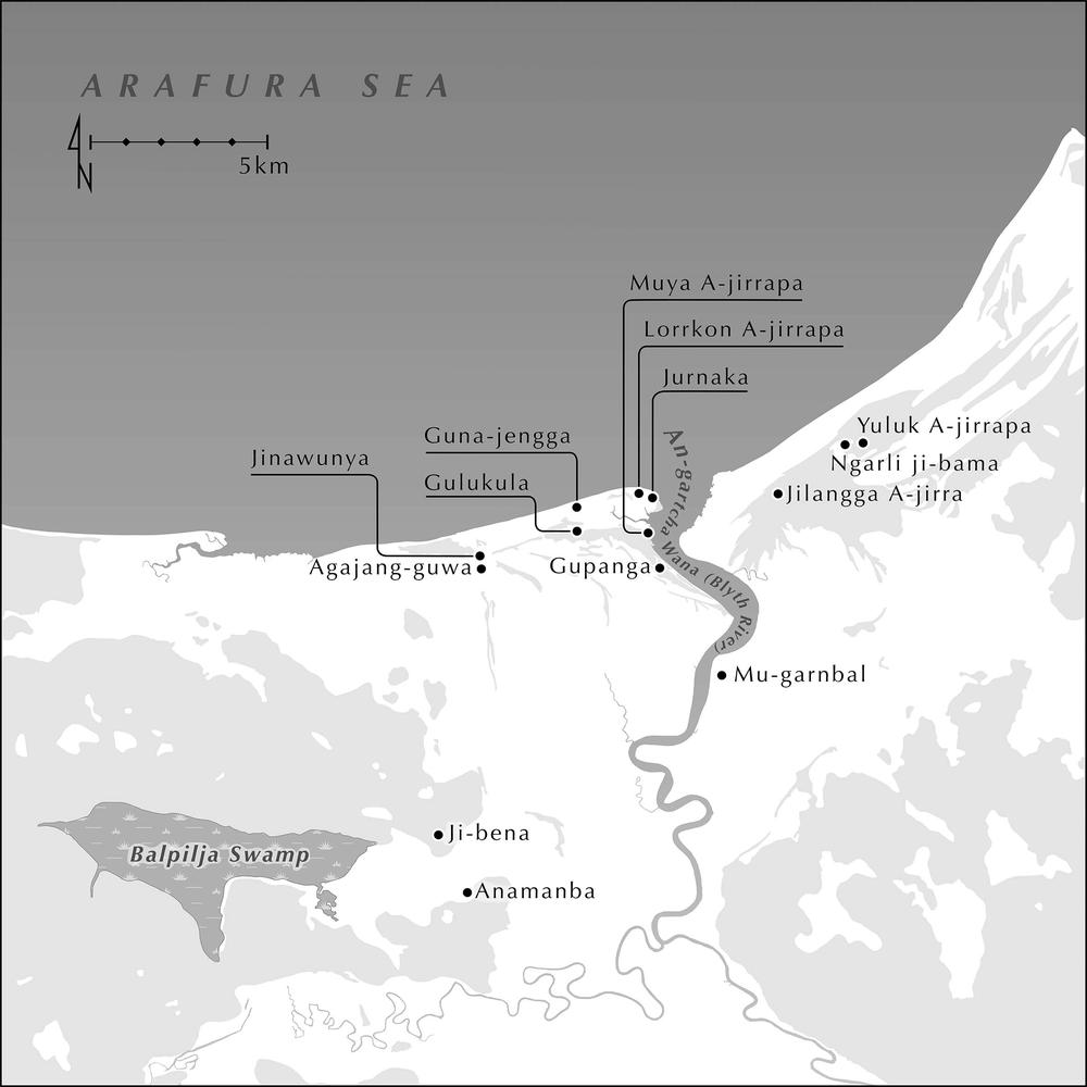
Map 3.1 Archaeological sites (Adam Black).
Chronology
Not all sites recorded by Betty and Rhys were selected for dating and analysis. The original dating of the excavation and sampling program undertaken in the 1970s was done by the ANU Radiocarbon Laboratory. In the 2000s, the Centre for Archaeological Research at ANU (CAR) provided funding for radiocarbon dates. Samples (shell and charcoal) were sent to the ANU Radiocarbon Laboratory and to the Waikato Radiocarbon Dating Laboratory in New Zealand. The results are listed in Table 3.1. Further dating and analysis of more sites is possible in the future, as there are suitable samples of charcoal and shell available, stored at MAGNT in Darwin.
| Site | Type | Sample | Code | Age C14 | Local Marine ΔR | Calibration Curve | Age cal BP 2σ |
|---|---|---|---|---|---|---|---|
| Mu-garnbal | Midden | Tegillarca granosa | Wk-17746 | 3625±40 | -141±36 | Marine 20 | 3724–3345 |
| Gupanga wangarr an-dakal a-yurra | Shell bed | D. juvenilis | ANU-2024 | 1890±90 | -141±36 | Marine 20 | 1695–1214 |
| Lorrkon a-jirrapa 1999 | Midden | Shell | Blyth 499 | 1710±60 | -141±36 | Marine 20 | 1433–1046 |
| Lorrkon a-jirrapa 1999 | Midden | Shell | Blyth 599 | 1460±80 | -141±36 | Marine 20 | 1228–772 |
| Lorrkon a-jirrapa West 1974 | Midden | D. juvenilis | ANU-2012 | 1440±70 | -141±36 | Marine 20 | 1179–750 |
| Lorrkon a-jirrapa West 1974 | Midden | Charcoal | ANU-2012 | 1190±155 | - | SHCal 20 | 1345–740 |
| Lorrkon a-jirrapa West 1978 | Midden | Dosinia sp. | Wk-24233 | 1460±36 | -141±36 | Marine 20 | 1166–821 |
| Muyu a-jirrapa | Shell midden | D. juvenilis | ANU-2014 | 1670±70 | -141±36 | Marine 20 | 1392–987 |
| Muyu a-jirrapa | Shell mound | D. juvenilis | ANU-2816 | 1580±100 | -141±36 | Marine 20 | 1356–867 |
| Jilangga a-jirra | Midden | D. juvenilis | ANU-2022 | 1430±110 | -140±36 | Marine 20 | 1235–703 |
| Jilangga a-jirra | Midden | Charcoal | ANU-2022 | 270±60 | - | SHCal 20 | 452–0* |
| Ji-bena 1/14 | Earth mound | D. juvenilis | ANU-2817 | 1510±100 | -141±36 | Marine 20 | 1284–790 |
| Ji-bena 1/13 | Earth mound | D. juvenilis | ANU-3417 | 1360±70 | -141±36 | Marine 20 | 1088–680 |
| Ji-bena 1 Auger/8-9 | Earth mound | D. juvenilis | ANU-3414 | 1250±80 | -141±36 | Marine 20 | 985–573 |
| Ji-bena 1/8 | Earth mound | D. juvenilis | ANU-3416 | 1260±70 | -141±36 | Marine 20 | 988–609 |
| Ji-bena 1/5 | Earth mound | D. juvenilis | ANU-3415 | 970±80 | -141±36 | Marine 20 | 710–333 |
| Agajang-guwa | Midden | D. juvenilis | ANU-11209 | 1350±60 | -140±36 | Marine 20 | 1060–683 |
| Gulukula 1974 | Shell mound | D. juvenilis | ANU-2021 | 1100±90 | -140±36 | Marine 20 | 875–465 |
| Gulukula 1978 | Shell mound | Dosinia sp. | Wk-24232 | 962±39 | -140±36 | Marine 20 | 666–392 |
| Gulukula 1999 | Shell mound | Dosinia sp. | Blyth 299 | 910±60 | -140±36 | Marine 20 | 641–312 |
| Anamanba | Earth mound | Geloina coaxans | ANU-11208 | 1050±80 | -141±36 | Marine 20 | 796–423 |
| Jinawunya 1983 | Midden | Dosinia sp. | ANU-11206 | 1030±60 | -140±36 | Marine 20 | 740–430 |
| Jinawunya 2015 | Midden | Anadara antiquata | Wk-42262 | 454±30 | 140±36 | Marine 20 | 40–0* |
| Yuluk a-jirrapa | Shell mound | D. juvenilis | ANU-2023 | 830±105 | -140±36 | Marine 20 | 636–165* |
| Yuluk a-jirrapa | Shell mound | Charcoal | ANU-2023 | 131.7±3.4 | - | SHCal 20 | 240–23* |
| Aningarra’s Camp | Midden | D. juvenilis | ANU-2013 | 740±70 | -141±36 | Marine 20 | 515–130* |
| Aningarra’s Camp | Midden | Charcoal | ANU-2013 | 310±130 | - | SHCal 20 | 505–0 |
| Guna-jengga | Midden | Charcoal | ANU-2020 | 290±105 | - | SHCal 20 | 495–0* |
| Guna-jengga | Midden | D. juvenilis | ANU-2020 | 600±105 | -140±36 | Marine 20 | 417–0* |
| Jurnaka | Midden | Dosinia sp. | Wk-24234 | 610±30 | -141±36 | Marine 20 | 373–14* |
| Ngarli ji-bama | Midden | Mactra abbreviata | Wk-17747 | 555±34 | -140±36 | Marine 20 | 286–0* |
| Calibrations performed via OxCal 4.4.4 [173] (Bronk Ramsey 2009, 2024) using Marine20 (Heaton et al. 2020) or SHCal 20 (Hogg et al. 2020). The local marine ΔR has been determined via Ulm et al. (2023) using approximate site coordinates (decimal lat/long). * “Date may extend out of range”. | |||||||
Table 3.1 Dates for An-gartcha Wana archaeological sites.
Agajang-guwa
Site description
Agajang-guwa is an area just south of Jinawunya where there is a shell midden on a transverse dune chenier running east–west.
Sampling
Rhys took a Dosinia juvenilis sample from the lower level of the midden in 1978.
Chronology
The sample returned a date of 1,060–683 cal BP (ANU-11209) (Table 3.1).
Anamanba
Site description
Anamanba lies on the eastern side of Balpilja Swamp (Maps 2.1 and 3.1). There is a large earth mound composed of termite nest and some shell lenses. This mound, like many others in the area including Ji-bena (see below), is on the bank of a freshwater billabong.
Sampling
Anamanba mound was augured by Jones and Chappell in 1999. Shell samples were collected from 2.3 m below the surface of the mound.
Chronology
A sample of Geloina coaxans (ANU-11208) returned a date of 796–423 cal BP (Table 3.1).
Aningarra’s Camp 1974
Site description
Michael Aningarra and his family camped on this shell midden, which sits on a coastal sand dune at Gupanga – a contemporary home base on the west bank near the mouth of An-gartcha Wana (Figure 2.1, Map 3.1). The upper levels of the midden were still occupied in 1974.
The beach berm on the north side of Kopanga has been eroded by the tide, exposing thick, tightly packed layers of shell midden that can be traced intermittently along the entire beach front, the present-day occupation adding daily to the deposit. [Michael] Aningarra’s [1972] camp was placed directly on a dense exposure of shell midden, one of his house posts being dug 30 cm into the deposit, which is almost 1 m thick at this point (Meehan 1982a,166).
This feature measures approximately 8 yds by 5 yds with a 5-yard diameter of hard packed shell, charcoal etc. The excavation revealed 3 distinct layers overlaying sand (RJ 1974 FN Bk 1, 67–8).
Excavation
In 1974, after clearing the surface, Betty and Rhys excavated a 50 × 50 cm square down to sterile sand and took two solid samples: Upper Level (0–6 cm), Lower Level (20–25 cm). The midden itself was very dense and contained much fine charcoal and ash with many shells that were burnt and crushed. The total depth of the excavation was 25 cm. The samples were later sieved through 1.5 mm mesh (RJ 1974, FN Bk 1, 63–5).
Chronology
Lower Level was dated from a Dosinia/charcoal pair (ANU-2013). A date of 515–130 cal BP was obtained on shell and 505–0 cal BP on charcoal (Table 3.1).
Results
There is a range of both marine and mangrove shellfish present in the upper and lower levels (Appendix 2). The dominant shellfish species by MNI are Dosinia and Marcia (Table 3.2), by NISP Dosinia and Modiolus and, by weight, Dosinia and Mactra. All are marine species, which dominated in both the upper and lower levels, with slightly more emphasis on marine in the lower levels. Mangrove species remain consistently less in both upper and lower levels (Figures 3.1–3.3).
| Marine | |||||||||
|---|---|---|---|---|---|---|---|---|---|
| XU | Depth (cm) | Dosinia | Marcia | Mactra | Modiolus | Volegalea | Tegillarca | Placamen | Total |
| UL | 0–6 | 62 | 14 | 5 | 5 | 5 | 2 | 1 | 94 |
| LL | 20–25 | 57 | 26 | 8 | 5 | 3 | 4 | 1 | 104 |
| Mangrove | |||||||
|---|---|---|---|---|---|---|---|
| XU | Depth (cm) | Cerithidea | Crassostrea | Geloina | Telescopium | Cassidula | Total |
| UL | 0–6 | 5 | 3 | 2 | 1 | 0 | 11 |
| LL | 20–25 | 1 | 2 | 0 | 0 | 1 | 4 |
Table 3.2 Aningarra’s Camp Shellfish taxa (MNI).
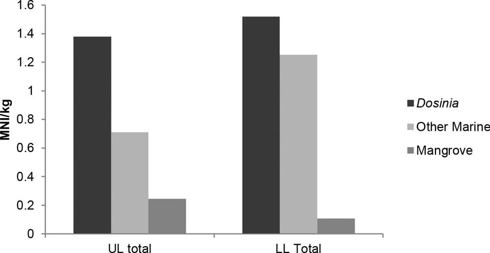
Figure 3.1 Aningarra’s Camp shellfish (MNI/kg deposit).

Figure 3.2 Aningarra’s Camp shellfish (NISP).
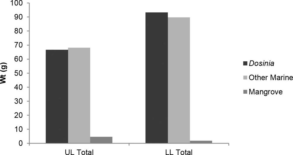
Figure 3.3 Aningarra’s Camp shellfish weight (g).
Gulukula Mounds 1974, 1978
Site description
The Gulukula chenier is the base for several large discrete shell mounds up to 5 m in height and 30 m in diameter (Map 2.1, Figure 3.4). Known as the Gulukula or Dog Mounds, they are the most famous on An-barra land. They lie inland, about 1 km from Guna-jengga on the present-day coast, and 2 km west of An-gartcha Wana (Map 3.1). “According to the An-barra, at some time in the past, the first dog in the country piled up these extensive mounds of shells with his paws, as dogs do with earth when they are digging a hole” (Meehan 1982a, 167).
Frank Gurrmanamana described the mounds as:
“Too much shell – can’t finish him.” To demonstrate this, Frank dug a small hole into the corner of one. He did not express any objection to our sampling the midden archaeologically. He thought one midden had grown higher since he was last here – the “Dreaming” is obviously still on-going. Frank expressly denied any human association for the middens – even the question of where the shells had come from (i.e. beach, mangrove etc.) was meaningless as the “Dog Dreaming” had formed them (RJ 1972, FN Bk 9, 18–19).
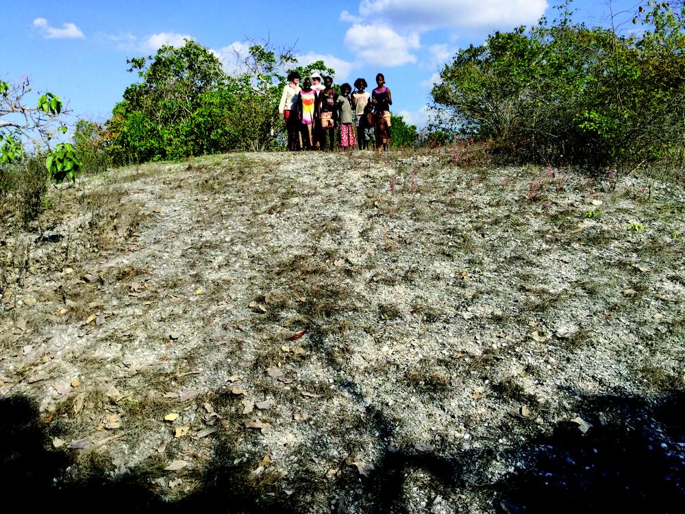
Figure 3.4 Gulukula 2015 (Bethune Carmichael).
Excavation
Gulukula was sampled twice, in 1974 and 1978. In 1974, Betty excavated a 50 × 50 cm test pit, 10 m from the top of one of the mounds that she describes as being the largest of the Gulukula shell mounds, 5 m high and 50 m wide. The pit was 25 cm in depth. Two solid samples were taken, Bags 1 and 2, as well as a dating sample from the bottom of the pit. There was shell only, no charcoal being obvious (BM 1974, FN Bk 2, 61). The deposit was sieved through 4 mm mesh. In 1978, a solid sample was taken 10 cm below the surface inside a goanna burrow (BM 1978, FN Bk 5, 29). Jones and Chappell took another sample from 25 cm depth in 1999.
Chronology
From Gulukula 1974, the shell (Dosinia) sample taken from 25 cm gave a date of 875–465 cal BP (ANU-2021). From Gulukula 1978, a shell sample (Dosinia) taken from 80 cm depth was dated to 666–392 cal BP (Wk-24232) (Table 3.1; Meehan 1983). In 1999, Jones and Chappell took another sample that was dated to 641–312 cal BP (Blyth 299) (Table 3.1).
Results
Gulukula 1974
Both marine and mangrove species (Appendix 2) were in the sample taken from the top of a Gulukula Mound in 1974. The dominant species by MNI, NISP and weight were marine, including Dosinia, Modiolus and Mactra (Table 3.3). In the sample taken from the side of a Gulukula Mound, Dosinia was the dominant species, and the other species appeared in negligible quantities.
| Marine | ||||||||||
|---|---|---|---|---|---|---|---|---|---|---|
| Dosinia | Modiolus | Mactra | Marcia | Tegillarca | Nassarius | Trisidos | Placamen | Tellina | Total | |
| Bag 1 | ||||||||||
| NISP | 282 | 91 | 36 | 16 | 2 | 4 | 1 | 1 | 1 | 434 |
| MNI | 141 | 46 | 18 | 8 | 2 | 4 | 1 | 1 | 1 | 222 |
| Wt (g) | 207 | 49 | 65 | 19.6 | 6.3 | 5.4 | 1.1 | 0.2 | 0 | 353.6 |
| Bag 2 | ||||||||||
| NISP | 339 | 2 | 6 | 5 | 0 | 0 | 0 | 0 | 0 | 352 |
| MNI | 170 | 1 | 5 | 3 | 0 | 0 | 0 | 0 | 0 | 179 |
| Wt (g) | 609.7 | 1.2 | 5.5 | 6.8 | 0 | 0 | 0 | 0 | 0 | 623.2 |
| Mangrove | |||||||
|---|---|---|---|---|---|---|---|
| Terebralia | Telescopium | Crassostrea | Cerithidea | Nerita | Cassidula | Total | |
| Bag 1 | |||||||
| NISP | 9 | 6 | 1 | 10 | 1 | 1 | 28 |
| MNI | 9 | 6 | 1 | 10 | 1 | 1 | 28 |
| Wt (g) | 21.6 | 33 | 12.9 | 7.3 | 1 | 0.6 | 76.4 |
| Bag 2 | |||||||
| NISP | 5 | 2 | 0 | 0 | 0 | 0 | 7 |
| MNI | 5 | 2 | 0 | 0 | 0 | 0 | 7 |
| Wt (g) | 20.4 | 1.7 | 0 | 0 | 0 | 0 | 22.1 |
Table 3.3 Gulukula 1974 Bags 1 & 2 Shellfish taxa MNI, NISP & Wt (g).
Gulukula 1978
Like the 1974 samples, the dominant species by MNI, NISP and weight were marine, dominated by Dosinia. The other species appeared in negligible quantities (Tables 3.4 and 3.5).
| Marine | |||||||||
|---|---|---|---|---|---|---|---|---|---|
| XU | Depth (cm) | Dosinia | Marcia | Mactra | Modiolus | Volegalea | Tegillarca | Placamen | Total |
| UL | 0–6 | 62 | 14 | 5 | 5 | 5 | 2 | 1 | 94 |
| LL | 20–25 | 57 | 26 | 8 | 5 | 3 | 4 | 1 | 104 |
| Mangrove | |||||||
|---|---|---|---|---|---|---|---|
| XU | Depth (cm) | Cerithidea | Crassostrea | Geloina | Telescopium | Cassidula | Total |
| UL | 0–6 | 5 | 3 | 2 | 1 | 0 | 11 |
| LL | 20–25 | 1 | 2 | 0 | 0 | 1 | 4 |
Table 3.4 Gulukula 1978 Shellfish taxa NISP, MNI & Wt (g).
| Marine | |||||||||||
|---|---|---|---|---|---|---|---|---|---|---|---|
| Dosinia | Modiolus | Mactra | Marcia | Nassarius | Saccostrea | Tegillarca | Placamen | Tellina | Trisidos | Total MNI | |
| 1974–1 | 141 | 46 | 18 | 8 | 4 | 1 | 2 | 1 | 1 | 1 | 223 |
| 1974–2 | 170 | 1 | 5 | 3 | 0 | 0 | 0 | 0 | 0 | 0 | 179 |
| 1978 | 239 | 9 | 16 | 0 | 2 | 2 | 1 | 0 | 0 | 0 | 269 |
| Mangrove | ||||||
|---|---|---|---|---|---|---|
| Cerithidea | Terebralia | Telescopium | Cassidula | Nerita | Total MNI | |
| 1974–1 | 10 | 9 | 6 | 1 | 1 | 27 |
| 1974–2 | 0 | 5 | 2 | 0 | 0 | 7 |
| 1978 | 0 | 3 | 7 | 0 | 0 | 10 |
Table 3.5 Gulukula 1974 and 1978 Comparison of shellfish taxa by habitat (MNI).
Guna-jengga 1974
Guna-jengga, 3 km west of Lalarr gu-jirrapa, is associated with an important fish trap, built across a creek flowing into the sea, which was used in the mid-dry season (Map 3.1; Meehan 1982a, 36, 113, 166). Frank Gurrmanamana said it is rrawa, a remembered camp site occupied during the “cold weather time” (i.e. not a Dreaming site) (RJ 1973, FN Bk 21, 26).
Rhys described Guna-jengga and the fish trap back in 1972:
Then we came to Gunedjanga a good camping place about ¾ mile west of Djunwinia – country belonging to George Fry (Darawolnga) (RJ 1972 FN, Bk 5, 8).
There is a well behind the beach berm and the remains of a hut on the beach… We went to where the fish trap was situated. Tommy remembered it in use when he was a little boy – say 10 or 12. There is a small stream – the upper portion of the one at Djinaka (RJ 1972 FN, Bk 5, 8–9).
The stream is tidally inundated even this far up. The stream at this point is in a well defined trench, 5 feet deep and perhaps 10 yds across. The trap was located on a narrow part on a corner… It consisted of a fence of vertical sticks with some kind of wickerwork woven through the sticks about 3 feet high. They formed a V shaped entrance to a funnel – which is a cylindrical basket through which the fish entered the trap – and when the tide went out, they could not find their way out again. Fish caught there were salmon fish, barramundi, “moon fish”, prawn, mullet, crab – “big mob”. On the other side (i.e. mouth) was a prominent midden with dense shell and charcoal about 2 feet thick in one place. The man who worked the trap lived here. People came to the trap to get fish – from Kopanga, Lalagidjiripa, Djunuwinia and even from Madangadjire too – and they took fish back in the same day. They brought other food in exchange. The man who worked it was George Fry’s father. He is dead now about 3 years ago at Maningrida (an old man). He was a man of this country. Maybe 2 or 3 men and their families used to camp here during the night to work the trap. During the day they would go and “sit down” on the beach etc. Other traps were situated on the same stream, both down and upstream – the latter during the rainy season. All the traps were made by George Fry’s father – according to Tommy (RJ 1972 FN, Bk 5, 9 –12).
We got back into the stream bed again and walked and searched westwards until we got to the SE corner of the big coastal sand dune facing the main place of Gunedjangga. Here we climbed the near vertical bank about 10 feet high. About 30–50 yds further west, the stream makes another twist which brings it against the dune wall again a cliff bank about 8–10 feet high. This is where old man Les Angabarapara used to have a fish trap. The channel is only about 15 feet wide at this point. Tommy Galpadanga told me that they used to camp on the dune near the beach – e.g. 200 yds away, and old man would go and get fish in his trap and bring it back. We walked onto the dune and rested for another smoko (5 mins) under a shady tree. All around us were patches of shells – all acknowledged to be dinner camps. This was part of Gunedjangga (RJ 1972 FN, Bk 8, 39).
On the Gunedjanga dune there is a well, still cleaned out, about 20 yds N/NW of where the old “Les” fish trap had been. This well was clean and had 1 baler by it, but there was no water in it. All day – we went without water (RJ 1972 FN, Bk 8, 44).
Betty described the use of the fish trap in April 1973:
… two species of crab and prawns contributed to the crustacea weight, many of these being caught in the fish trap at Gunadjeng-ga. Five species of shark and stingray and 16 other species of fish contributed 500 kg gross weight to the diet in April – again, much of this came from the fish trap at Gunadjenga-ga (Meehan 1982a, 153).
She went on to say, however, that it was not always reliable:
Everyone who walks to Guna-jengga hopes to have a substantial meal consisting of seafood from the fish trap but may eventually have to gather Mactra meretriciformis [now M. abbreviata] and Dosinia juvenilis because the trap is found to be empty, and several other strategies fail (Meehan 1982a, 112).
Site description
The archaeological site of Guna-jengga is a coastal midden consisting of a modern “dinner time” camp overlying an older midden deposit (Figure 3.5). The site is about 200 m from the beach where there is a well behind the beach berm.
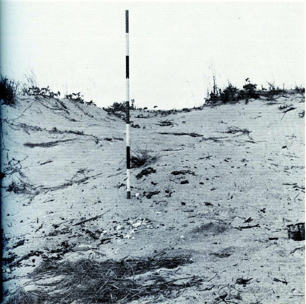
Figure 3.5 Guna-jengga (Rhys Jones).
Rhys described the site in 1973:
Given the narrowness of the dunes here – pinched between the sea and the tidal creek behind – viz. only about 50 – 60 yds… this is the only place to camp. During high tides, there would be no foreshore and people would be forced back on the narrow shelf on the front (seaward) slope of the dunes or in little swales amongst them – i.e. exactly where the old midden now is, plus the present dinner camp. All the beach camp debris would be obliterated by the king tide and so all that is left is the occupation debris on the front apron of the dunes. In this way, the midden corresponds exactly to the front of the Lalargedjiripa occupied by the “permanent” Anbarra (and in a different place – Madai) houses, just above the king tide – to which they all shift during high tides – and from which they fan out to the beach during weak tides. The only difference is that the sand behind the camp at Lala… is flat – that at Gunedjanga forms a narrow and tussocky, quite steep little ridge – squeezing any occupation tightly to the beach front (RJ 1973, FN Bk 23, 5–6).
To the west of the tree, from about 10 yds to 50/60 yds west of it and exactly at the same “height” above sea level – as the tree and the “dinner time camp” site – is an outcrop of dense shell midden. This is between 6" and 9" thick and is continuous, in outcrop over 50 yds… In places, the surface of this midden is exposed at the present surface – in the places it is overlain by some recent dune sand. I estimate that its age would be anything from say 25/50 yrs old to 100/150 yrs old (RJ 1973, FN Bk 21, 26–7).
This midden lens is exposed along the dune front for a length of about 60 yds, the eastern edge of it coming to where the present dinner camp is… The present camp debris is laid directly on top of this midden on the west edge of the “dinner camp” and separated from it by about 2–4" of fresh white sand in the east. In the east, the old midden has also been cut away in places by modern wind blown swales plus the dinner camp debris laid on the floor of the “clean” sands thus formed. Thus, both the older midden and the present dinner camp would be recognised archaeologically as belonging to different episodes – but they would be seen as two lenses or units of a single midden (RJ 1973, FN Bk 23, 3–5).
In 1974, Rhys reflected on storm damage at Guna-jengga:
Passing the Gunedjangga fishing trap tree, we noticed that heavy winds/waves had eroded the fore-dune slope and half exposed the roots of the shade tree. The interesting thing is that the long exposure of shell midden, noted in our previous survey, is now revealed to go right underneath the roots of the tree and right underneath the dinner time camp on which we had rested and dined, and left our own debris… The midden itself, we had sampled – solid and C14 samples. Thus, we have two deposits now stratified directly above each other, separated by sand. The lower prehistoric one – C14 samples – and the upper one, for which we and our companions are responsible. The upper one is now itself under about two feet of sand… In the coastal dune exposure, we could see the shell midden (the prehistoric one which we had sampled) extending continuously over about 800–1,000 metres (RJ 1974, FN Bk 2, 14–15).
Sampling
In 1974, Rhys sampled the midden:
Betty and I cleaned up a section of the shell midden outcropping about 30–40 yds west of the fish trap “dinner time” camp under the tree on the beach.
Firstly, we cleaned up a section wall about 10 ft long, revealing a dense shell midden layer about 4–6" thick… We then got a C14 sample from it – picking out the charcoal bits with a clean trowel into a plastic bag. Then we took 2 solid soil samples. While excavating, we found a strongly cemented ashy hearth about 1½" thick and 12–15" in diameter. This was on the east side of our section starting about 1" in from the first exposed wall (Figure 3.6).
This midden lens is exposed along the dune front for a length of about 60 yds, the eastern edge of it coming to where the present dinner camp is (RJ 1973, FN Bk 23, 3–5).

Figure 3.6 Rhys Jones in the Guna-jengga section (Betty Meehan).
Chronology
Rhys speculated on the age of the site when he took the sample: “My guess is that the date will prove to be significantly different from ‘modern’ but will not have a large antiquity – i.e. of the order of 200–400 yrs BP” (RJ 1973, FN Bk 23, 4). He proved to be correct. A Dosinia/charcoal pair (ANU-2020) returned an age of 495–0 and 417–0 cal BP respectively (Table 3.1).
Results
Again, the dominant shellfish is marine, Dosinia (Table 3.6, Figure 3.7).
| Marine | ||||||||
|---|---|---|---|---|---|---|---|---|
| Dosinia | Tellina | Modiolus | Mactra | Marcia | Tegillarca | Placamen | Total | |
| NISP | 251 | 53 | 50 | 9 | 2 | 2 | 1 | 368 |
| MNI | 127 | 27 | 3 | 2 | 2 | 1 | 1 | 163 |
| Wt (g) | 120.1 | 9.7 | 4.4 | 4.2 | 3.1 | 0.6 | 0.2 | 142.3 |
| Mangrove | |||||
|---|---|---|---|---|---|
| Cerithidea | Geloina | Telescopium | Crassostrea | Total | |
| NISP | 22 | 1 | 1 | 1 | 25 |
| MNI | 9 | 1 | 1 | 1 | 12 |
| Wt (g) | 3.6 | 1 | 0.5 | 0.4 | 5.5 |
Table 3.6 Guna-jengga Shellfish taxa NISP, MNI & Wt (g).
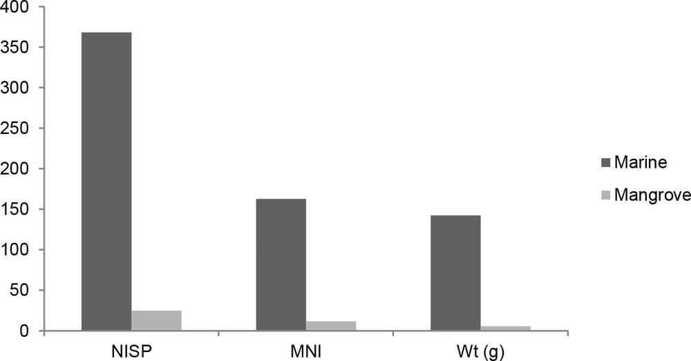
Figure 3.7 Guna-jengga Shellfish habitat NISP, MNI & Wt (g).
Gupanga wangarr an-dakal a-yurra (where the Dreaming white ochre representing diyama lies)
This site is a fossilised shell bed cemented by coarse calcareous sand, containing a mix of shells including Dosinia and Marcia, exposed intertidally 400 m north of Gupanga (Map 3.1; Meehan 1982a, 56).
Rhys described it as follows:
This “shell rock” is called Andakul… and it is the real “dreaming” of diyama (An + Dua). This Andakal is smashed up and the names of places are called out, where it is desired that the diyama will grow. They go “dji, dji, dji, dji, dji, dji ” [which is the cry of the whistle duck], then call out the names – Lalargedjiripa, Moganara etc. etc. (RJ 1973, FN Bk 16, 72–3).
Betty notes:
The whistle duck is significant in relation to diyama as the patterns on the shells are reminiscent of the markings on the ducks (Meehan 1982a, 52–3).
Chronology
A Dosinia sample (ANU-2024) returned an age of 1,695–1,214 cal BP (Table 3.1).
Ji-bena 1979
The earth mound Ji-bena is in open woodland adjacent to the freshwater swamp, Balpilja, and close to the mangroves lining An-gartcha Wana. It is now 8 km from the sea (Maps 2.1, 2.2 and 3.1, Figure 3.8). It is a large circular earth mound approximately 80 m in diameter and 2 m high (Figure 3.9). According to Frank Gurrmanamana, it was occupied in the late wet season (RJ 1979, FN Bk 1, 79).
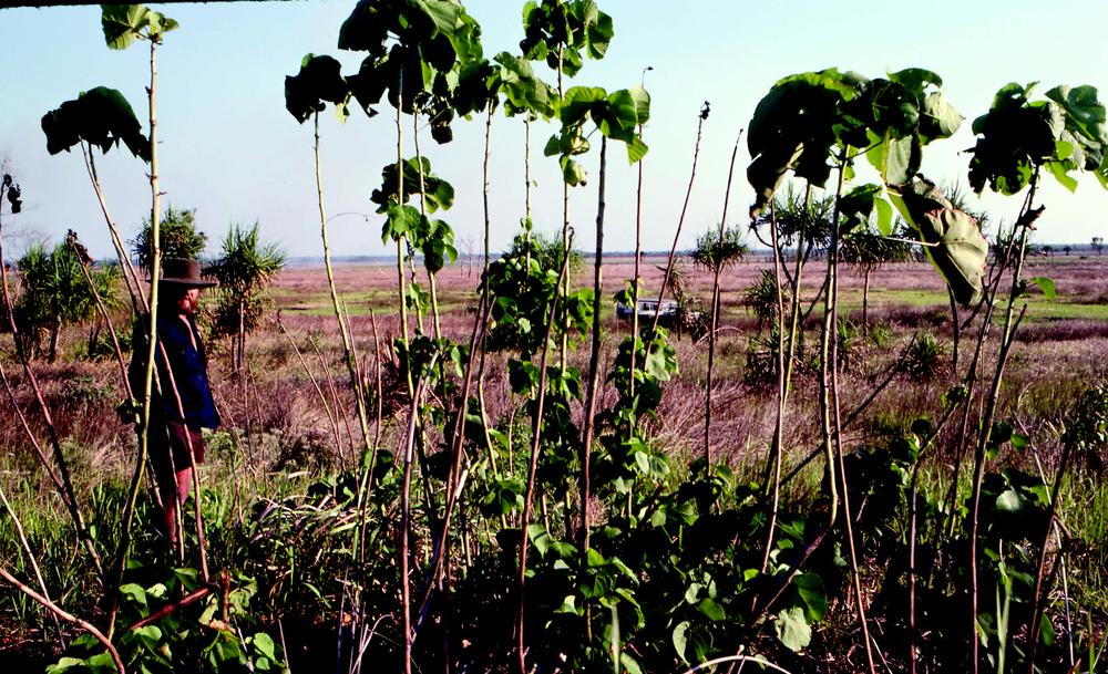
Figure 3.8 Rhys Jones at the location of Ji-bena (Betty Meehan).
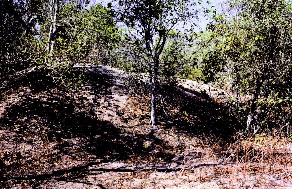
Figure 3.9 Rhys Jones at Ji-bena earth mound (Betty Meehan).
Excavation
In 1979, Betty and Rhys excavated a metre square test pit in 15 spits that reached 1.65 m in depth (Figures 3.10 and 3.11) (BM 1979, FN Bk 1, 51–89; RJ 1979, FN Bk 1, 57–9, 82–9).
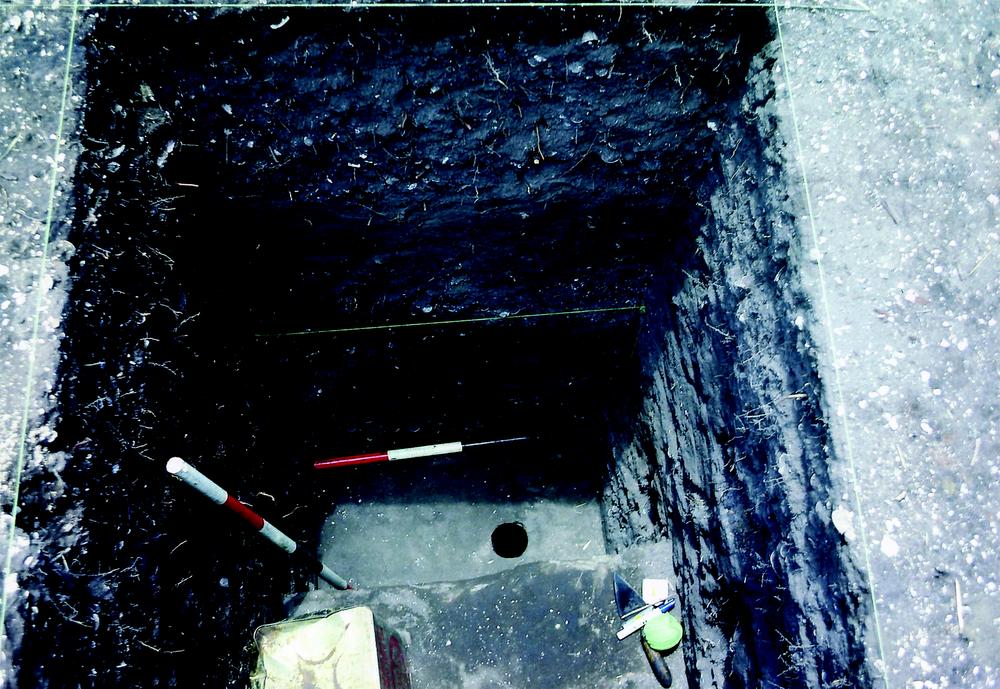
Figure 3.10 Ji-bena excavation (Rhys Jones).

Figure 3.11 Ji-bena section (Billy Ó Foghlú).
Chronology
Ji-bena was dated to 1,284–790 cal BP (ANU-2817), 10 cm above base. Four other sequential dates were obtained, the youngest being 710–333 cal BP (ANU-2815), 50 cm below the surface (Table 3.1; Brockwell et al. 2005; Meehan 1988a; White et al. 1990).
Results
Shell, bone and stone artefacts were recovered from the Ji-bena excavation. Relative quantities are recorded in Table 3.7. Two pieces of glass were also found in Spit 1, maximum depth 8 cm.
| XU | XU Wt (kg) | Spit Size (cm) | Depth (cm) | Shell Wt (g) | Bone Wt (g) | Stone Wt (g) |
|---|---|---|---|---|---|---|
| 1 | 120 | 8 | 8 | 37.7 | 45.9 | 376.1 |
| 2 | 210 | 14 | 24 | 23 | 54.1 | 44.2 |
| 3 | 150 | 10 | 33 | 94.7 | 22.3 | 149.7 |
| 4 | 225 | 15 | 48 | 14.3 | 53.4 | 311.2 |
| 5 | 120 | 8 | 55 | 1.4 | 23 | 11.5 |
| 6 | 240 | 16 | 73 | 22.3 | 5.8 | 534.7 |
| 7 | 195 | 13 | 86 | 484.6 | 0.2 | 0.5 |
| 8 | 210 | 14 | 100 | 997.4 | 0 | 48.7 |
| 9 | 165 | 11 | 111 | 1065.6 | 0.8 | 6.8 |
| 10 | 195 | 13 | 123 | 1010.3 | 0 | 2.8 |
| 11 | 210 | 14 | 136 | 544.3 | 0.5 | 1.2 |
| 12 | 150 | 10 | 148 | 713.3 | 0 | 0 |
| 13 | 165 | 11 | 160 | 1364.7 | 0 | 0 |
| 14 | 90 | 6 | 165 | 972.3 | 0 | 3.8 |
| 15 | 30 | 2 | 169 | 7 | 0.1 | 0 |
| Total | 2475 | - | - | 7352.9 | 228.7 | 1491.2 |
Table 3.7 Ji-bena Quantitative data.
Shell
Twenty taxa were identified: the marine taxa Dosinia, Modiolus, Mactra, Nassarius, Tellina, Volema, Tegillarca, Marcia, Saccostrea, Volegalea, Neverita, Melo amphora, Cymbiola and Syrinx; the mangrove taxa Cerithidea, Telescopium, Terebralia, Geloina, Cassidula; and the terrestrial taxon Xanthomelon. The relative proportions of taxa are shown in Table 3.8. They are listed with the numerous species first. Dosinia juvenilis dominated the assemblage by MNI and weight. Marine shellfish dominated until c. 700 years BP when they disappeared from the assemblage (Figure 3.12).
| Taxon | MNI | Wt (g) | % MNI | % Wt | |
|---|---|---|---|---|---|
| Marine | Dosinia | 1474 | 4011.7 | 80.2 | 56.7 |
| Modiolus | 122 | 88.9 | 6.6 | 1.3 | |
| Mactra | 40 | 144.6 | 2.2 | 2 | |
| Nassarius | 39 | 26.1 | 2.1 | 0.4 | |
| Tellina | 12 | 21.4 | 0.7 | 0.3 | |
| Volema | 8 | 14.3 | 0.4 | 0.2 | |
| Tegillarca | 7 | 31.4 | 0.4 | 0.4 | |
| Marcia | 7 | 28.3 | 0.4 | 0.4 | |
| Saccostrea | 6 | 33.4 | 0.3 | 0.5 | |
| Volegalea | 6 | 24.7 | 0.3 | 0.3 | |
| Neverita | 6 | 10.1 | 0.3 | 0.1 | |
| Melo amphora | 5 | 52.7 | 0.3 | 0.7 | |
| Cymbiola | 5 | 1.7 | 0.3 | 0 | |
| Syrinx | 1 | 6.3 | 0.1 | 0.1 | |
| barnacle | 1 | 0.8 | 0.1 | 0 | |
| Mangrove | Cerithidea | 59 | 34.9 | 3.2 | 0.5 |
| Telescopium | 51 | 308.7 | 2.8 | 4.4 | |
| Terebralia | 40 | 83.9 | 2.2 | 1.2 | |
| Geloina | 21 | 419 | 1.1 | 5.9 | |
| Cassidula | 17 | 25.8 | 0.9 | 0.4 | |
| Terrestrial | Xanthomelon | 8 | 19.1 | 0.4 | 0.3 |
| No ID | - | 1743.6 | - | - | |
| Total | 1935 | 7131.4 | - | - | |
Table 3.8 Ji-bena Total shellfish taxa MNI & Wt (g).
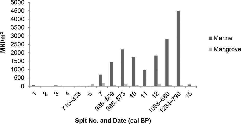
Figure 3.12 Ji-bena Chronological distribution of shellfish (MNI/m3).
Other faunal material
A total of 206.1 g of bone was recovered from the Ji-bena excavation. Most bone was found in the upper part of the excavation post c. 500 years BP. The distribution is recorded in Table 3.9 and Figure 3.13.
| Spit No. | Date (cal BP) | Vol. (m3) | Wt (g) | Wt (g/m3) |
|---|---|---|---|---|
| 1 | - | 0.08 | 45.9 | 573.8 |
| 2 | - | 0.16 | 54.1 | 338.1 |
| 3 | - | 0.09 | 16.6 | 184.4 |
| 4 | - | 0.15 | 53.4 | 356 |
| 5 | 710–333 | 0.07 | 23 | 328.6 |
| 6 | - | 0.18 | 5.8 | 32.2 |
| 7 | - | 0.13 | 0.2 | 1.5 |
| 8 | 988–609 | 0.14 | 0 | 0 |
| 9 | 985–573 | 0.11 | 0.8 | 7.3 |
| 10 | - | 0.12 | 0 | 0 |
| 11 | - | 0.13 | 0.5 | 3.8 |
| 12 | - | 0.12 | 0 | 0 |
| 13 | 1088–680 | 0.12 | 0 | 0 |
| 14 | 1284–790 | 0.05 | 0 | 0 |
| 15 | - | 0.04 | 0.1 | 2.5 |
| Total | 1.69 | 200.4 | 1828.2 | |
Table 3.9 Ji-bena Chronological distribution of bone (g/m3 of deposit).
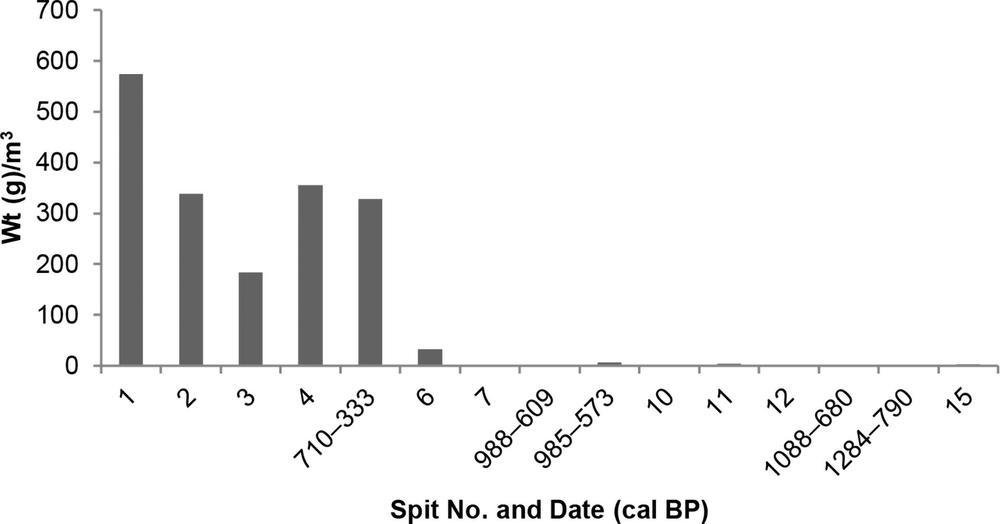
Figure 3.13 Ji-bena Chronological distribution of bone (wt g/m3).
Turtle was the dominant taxon, followed by mammal, fish, reptile and bird (Table 3.10). Identified mammal bone includes the teeth and jaws of the northern brushtail possum (Trichosurus arnhemensis), northern brown bandicoot (Isoodon macrourus), an unspecified rodent and macropod. Fish bones include the vertebrae, spines and cranium of two common north Australian fish, the fork-tailed catfish (Arius sp.) and barramundi (Lates calcarifer). Both species can live in either fresh or saltwater. Neither bird (long bones) nor reptile remains (vertebrae) could be identified to family or species level. Freshwater taxa (turtle) became dominant in the assemblage c. 700 years ago until the recent past (Figure 3.14).
| Spit No. | Date (cal BP) | Vol. (m3) | Turtle (g/m3) | Mammal (g/m3) | Fish (g/m3) | Reptile (g/m3) | Bird (g/m3) | No ID (g/m3) |
|---|---|---|---|---|---|---|---|---|
| 1 | - | 0.08 | 155 | 37.5 | 10 | 0 | 17.5 | 353.8 |
| 2 | - | 0.16 | 75.6 | 58.8 | 25 | 23.8 | 8.1 | 146.9 |
| 3 | - | 0.09 | 81.1 | 12.2 | 8.9 | 6.7 | 2.2 | 73.3 |
| 4 | - | 0.15 | 131.3 | 4 | 14 | 18.7 | 1.3 | 186.7 |
| 5 | 710–333 | 0.07 | 210 | 17.1 | 1.4 | 8.6 | 0 | 91.4 |
| 6 | - | 0.18 | 26.1 | 1.1 | 0 | 0.6 | 0 | 4.4 |
| 7 | - | 0.13 | 0 | 0.8 | 0 | 0 | 0 | 0.8 |
| 8 | 988–609 | 0.14 | 0 | 0 | 0 | 0 | 0 | 0 |
| 9 | 985–573 | 0.11 | 0 | 0 | 0 | 0 | 0 | 7.3 |
| 10 | - | 0.12 | 0 | 0 | 0 | 0 | 0 | 0 |
| 11 | - | 0.13 | 0 | 0 | 0 | 0 | 0 | 3.8 |
| 12 | - | 0.12 | 0 | 0 | 0 | 0 | 0 | 0 |
| 13 | 1088–680 | 0.12 | 0 | 0 | 0 | 0 | 0 | 0 |
| 14 | 1284–790 | 0.05 | 0 | 0 | 0 | 0 | 0 | 0 |
| 15 | - | 0.04 | 0 | 0 | 0 | 0 | 0 | 2.5 |
| Total | 1.69 | 679.1 | 131.5 | 59.3 | 58.4 | 29.1 | 870.9 | |
Table 3.10 Ji-bena Chronological distribution of vertebrate fauna (g/m3 of deposit).
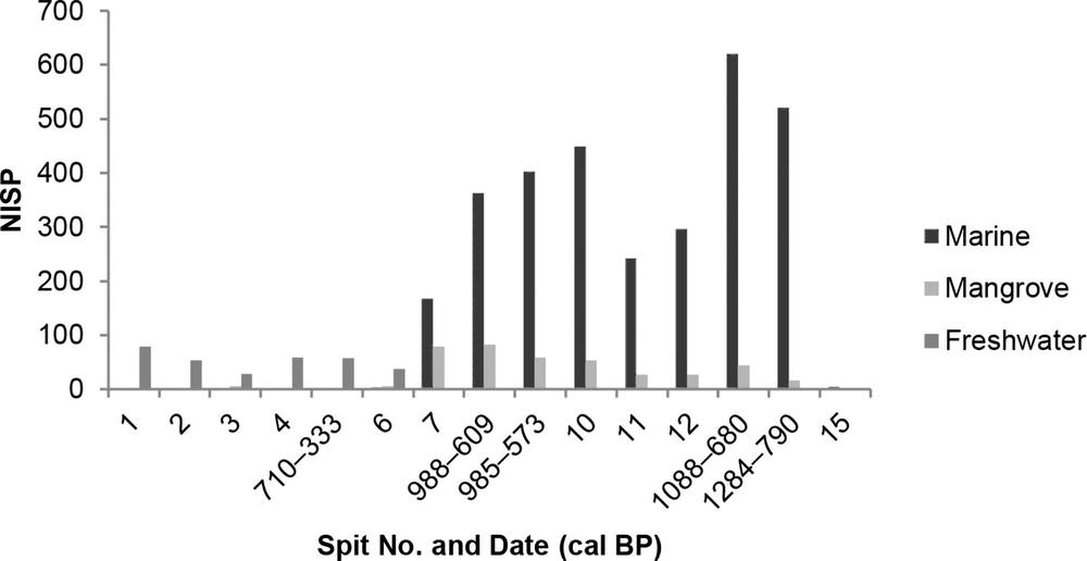
Figure 3.14 Ji-bena Chronological distribution of fauna by habitat (NISP).
Stone assemblage
Altogether there were 71 stone artefacts weighing 1,496.9 g recovered from the excavation at Ji-bena, with an average density of 46.5 artefacts per cubic metre. The artefacts were concentrated in the upper part of the site post 500 years BP (Table 3.11, Figure 3.15). The most common item was flaked quartzite, including one quartzite bipolar core. There were also some ground ochre, haematite and sandstone artefacts (Table 3.12).
| Spit No. | Date (cal BP) | No. of Artefacts | Wt (g) | Vol. (m3) | No./m3 |
|---|---|---|---|---|---|
| 1 | - | 19 | 376.1 | 0.08 | 237.5 |
| 2 | - | 9 | 44.2 | 0.14 | 64.3 |
| 3 | - | 6 | 155.4 | 0.1 | 60 |
| 4 | - | 18 | 311.2 | 0.15 | 120 |
| 5 | 710–333 | 5 | 11.5 | 0.08 | 62.5 |
| 6 | - | 2 | 534.7 | 0.16 | 12.5 |
| 7 | - | 1 | 0.5 | 0.13 | 7.7 |
| 8 | 988–609 | 7 | 48.7 | 0.14 | 50 |
| 9 | 985–573 | 4 | 6.8 | 0.11 | 36.4 |
| 10 | - | 3 | 2.8 | 0.13 | 23.1 |
| 11 | - | 2 | 1.2 | 0.14 | 14.3 |
| 12 | - | 0 | 0 | 0.1 | 0 |
| 13 | 1088–680 | 0 | 0 | 0.11 | 0 |
| 14 | 1284–790 | 1 | 3.8 | 0.06 | 16.7 |
| 15 | - | 0 | 0 | 0.02 | 0 |
| Total | 77 | 1496.9 | 1.65 | 46.7 | |
Table 3.11 Ji-bena Chronological distribution of stone artefacts (no. & g/m3 of deposit).

Figure 3.15 Ji-bena Chronological distribution of stone artefacts (no./m3).
| Spit No. | Date (cal BP) | Quartzite | Sandstone | Silcrete | Ochre | Haematite | Shale | Chert |
|---|---|---|---|---|---|---|---|---|
| 1 | - | 10 | 2 | 3 | 3 | 1 | 0 | 0 |
| 2 | - | 7 | 2 | 0 | 0 | 0 | 0 | 0 |
| 3 | - | 5 | 0 | 0 | 1 | 0 | 0 | 0 |
| 4 | - | 12 | 2 | 1 | 0 | 1 | 2 | 0 |
| 5 | 710–333 | 3 | 1 | 1 | 0 | 0 | 0 | 0 |
| 6 | - | 1 | 0 | 1 | 0 | 0 | 0 | 1 |
| 7 | - | 1 | 0 | 0 | 0 | 0 | 0 | 0 |
| 8 | 988–609 | 6 | 0 | 0 | 0 | 0 | 0 | 0 |
| 9 | 985–573 | 4 | 0 | 0 | 0 | 0 | 0 | 0 |
| 10 | - | 3 | 0 | 0 | 0 | 0 | 0 | 0 |
| 11 | - | 2 | 0 | 0 | 0 | 0 | 0 | 0 |
| 12 | - | 0 | 0 | 0 | 0 | 0 | 0 | 0 |
| 13 | 1088–680 | 0 | 0 | 0 | 0 | 0 | 0 | 0 |
| 14 | 1284–790 | 1 | 0 | 0 | 0 | 0 | 0 | 0 |
| 15 | - | 0 | 0 | 0 | 0 | 0 | 0 | 0 |
| Total | 55 | 7 | 6 | 4 | 2 | 2 | 1 | |
Table 3.12 Ji-bena Chronological distribution of lithic raw materials (nos).
Jilangga a-jirra
Jilangga a-jirra is located 3 km from the eastern bank of An-gartcha Wana, and about 1 km from the coast (Map 3.1). There is a thin shell midden scatter, located on top of an inland vegetated dune running parallel to the coast. It lies adjacent to a large shell mound, which is a wet season camp belonging to the Gu-lalay who are related to the An-barra. Stone tools were observed on the surface of the midden, along with mammal and fish bones (Meehan 1982a, 38, 163).
Sampling
A dating sample was taken 15–20 cm from the top of the midden, which had been dug out to make a cooking pit for six wallabies.
Chronology
A Dosinia/charcoal pair (ANU-2022) returned dates of 1,235–703 cal BP and 452 to modern cal BP (Table 3.1). The discrepancy in dates could be due to sampling from disturbed deposit.
Jinawunya 1978
Jinawunya is a coastal area on the western side of An-gartcha Wana, on the western margin of An-barra land near the Gulukula shell mounds (Map 3.1, Figure 3.16; Meehan 1982a, 12). It is a camping place, popular for shell-fishing and fishing, and for collecting Pandanus nuts, vegetables, fruit and wood from trees on the chenier dune behind the beach (Map 2.1). Rhys and Betty made an archaeological transect here (Meehan 1982a, 107, 110–11, 165; BM 1978 FN, Bk 5, 39–44). No excavation was undertaken at Jinawunya but dating samples were taken from the large shell midden on a dune adjacent to the beach.
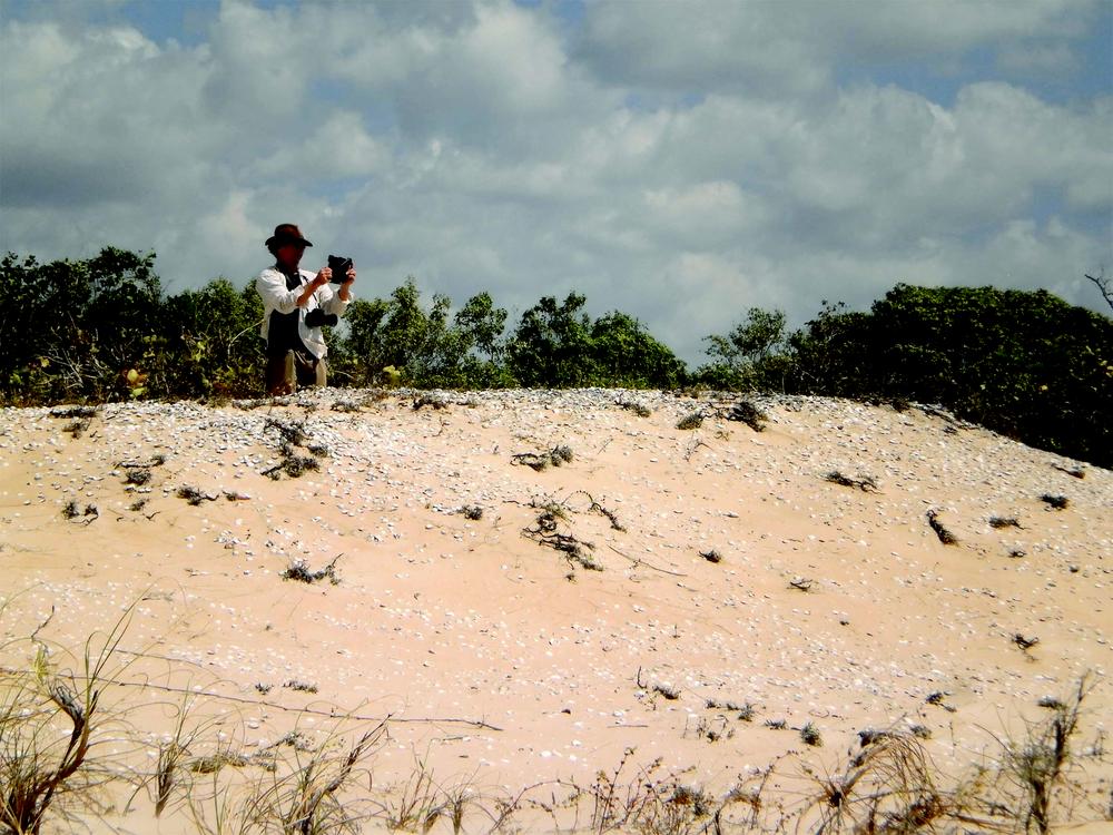
Figure 3.16 Bethune Carmichael at Jinawunya (Sally Brockwell).
In 1983, Rhys collected a shell sample (Dosinia juvenilis) from 20–30 cm below the surface of the midden. We visited Jinawunya in 2015 and collected a shell sample (Anadara antiquata) from the surface of the midden, which had been half eroded away by wave action (Figure 3.16). This was the same place where doctoral student Bethune Carmichael (2015) interviewed Betty Ngurrpangurrpa for his film Places in Peril regarding her perceptions of climate change. We also collected recently dead shells to be compared with archaeological samples in an isotope analysis study to investigate late Holocene changes in sea surface temperatures.
Chronology
The 1983 shell sample (ANU-11206) was dated to 740–430 cal BP. The 2015 sample (Wk-42262) returned a date of 40–0 cal BP (Table 3.1). The discrepancy in dates is likely due to sampling, as the 1983 sample was taken from below the surface and the 2015 sample from the surface.
Jurnaka 1978
Jurnaka (meaning corner) is located on the coast, west of the mouth of An-gartcha Wana in a mangrove area, near where Jurnaka Creek flows into it (Map 3.1). A shell mound, measuring 24 × 25 m, was deposited on a small natural rise on the coast. A nearby modern midden contained diyama (Marcia) and mussels on the surface. The maximum depth of the mound was 0.5 m. There was clean sand underneath, then dense midden to the surface (BM 1978, FN Bk 5, 21–6).
Although oysters (Saccostrea) were not important to the An-barra diet in terms of quantity, they were highly prized and sought after. Called an-guljaraba, they come from mangrove areas around the mouth of An-gartcha Wana, one of the most popular areas being Jurnaka. Betty explains:
The Djunaka area has been heavily exploited in the recent past. Although in this area shells are small and no longer abundant compared with other areas exploited during the year, it is still used because of its accessibility. The oysters occur in clusters on the trunks of mangrove trees or lie on the mud between them. As men frequently use the Djunaka area for line and spear-fishing children tend to play in the adjacent mangroves where they collect C. amasa [S. pyschophilla], as well as Nerita lineata and Volegalea wardiana (Meehan 1982a, 99).
Approximately 82 kg of the 354 kg of fish caught during January [1973] consisted of four species of stingray; 20 other species of fish made up the remaining 272 kg. Much of the fishing was done at the mouth of the Djunaka creek with a long net (Meehan 1982a, 153).
Sampling and excavation
The following description of the excavation of the shell mound is taken from Meehan (BM 1978, FN Bk 5, 21–6).
0–35 cm – dense shell midden; burnt and broken shell
35–37 cm – a layer of grey ash, fewer shells
37–40 cm – two lenses, one 35 cm wide merging into an ash lens 45 cm wide (horizontal features)
40–46 cm – grey sand with large shells in it; some whole shells on soft dune – “first guys there”?
50 cm – basal yellow sand
We then took two solid samples – one from the “top” [1–10 cm] and one from the “bottom” [41–48 cm]. We also took charcoal samples from the same units. We also took a sieved shell sample (fine sieved, 2 mm) [6–14 cm]. There was some rootlet penetration in both top and bottom samples (BM 1978 FN, Bk 5, 20–1).
Chronology
A Dosinia sample was taken from the base of the shell mound and dated to 373–14 cal BP (Wk-24234) (Table 3.1).
Results
The dominant shellfish was Dosinia with other species appearing in low quantities (Table 3.13, Figure 3.17).
| Marine | ||||||||
|---|---|---|---|---|---|---|---|---|
| Dosinia | Mactra | Placamen | Marcia | Modiolus | Nassarius | Tegillarca | Total | |
| Bag 1, 1–10 cm Bulk Sample | ||||||||
| NISP | 97 | 0 | 1 | 1 | 0 | 2 | 1 | 102 |
| MNI | 49 | 0 | 1 | 1 | 0 | 2 | 1 | 54 |
| Wt (g) | 119.8 | 0 | 1.1 | 3.9 | 0 | 0.6 | 0.6 | 126 |
| Bag 2, 6–14 cm Sieved Sample | ||||||||
| NISP | 128 | 4 | 3 | 0 | 0 | 0 | 0 | 135 |
| MNI | 64 | 3 | 2 | 0 | 0 | 0 | 0 | 69 |
| Wt (g) | 202.41 | 13.1 | 2.7 | 0 | 0 | 0 | 0 | 218.21 |
| Bag 3, 41–48 cm Bulk Sample | ||||||||
| NISP | 123 | 6 | 1 | 3 | 3 | 0 | 1 | 137 |
| MNI | 62 | 3 | 1 | 2 | 2 | 0 | 1 | 71 |
| Wt (g) | 113.1 | 15.5 | 0.3 | 9.3 | 0.9 | 0 | 10.7 | 149.8 |
| Mangrove | |||
|---|---|---|---|
| Cerithidea | Terebralia | Total | |
| Bag 1, 1–10 cm Bulk Sample | |||
| NISP | 0 | 0 | 0 |
| MNI | 0 | 0 | 0 |
| Wt (g) | 0 | 0 | 0 |
| Bag 2, 6–14 cm Sieved Sample | |||
| NISP | 0 | 1 | 1 |
| MNI | 0 | 1 | 1 |
| Wt (g) | 0 | 1.3 | 1.3 |
| Bag 3, 41–48 cm Bulk Sample | |||
| NISP | 3 | 0 | 3 |
| MNI | 3 | 0 | 3 |
| Wt (g) | 1.6 | 0 | 1.6 |
Table 3.13 Jurnaka 1978 Bags 1, 2 & 3 Distribution of shellfish taxa NISP, MNI, Wt (g).
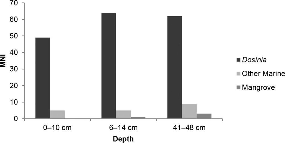
Figure 3.17 Jurnaka Distribution of shellfish taxa by habitat (MNI).
Lorrkon a-jirrapa East and West 1974
The Lorrkon a-jirrapa coastal shell middens are located on a chenier ridge 3 km from the western bank of An-gartcha Wana and 2 km from the coast (Maps 2.1 and 3.1). The northern edge is bordered by a salt clay pan, and the southern side is black soil plain. A jungle vine thicket is situated at its base. The midden area is extensive, over 400 m long and 3 m high.
Betty and Rhys describe the site:
The Larrakun-adjirripa area is very midden rich. We found four quartzite flakes on the surface without really looking (BM 1978, FN Bk 5, 2).
… I came to the East/West dune. Here the berm of the dune is encased in an almost continuous capping of dense shell midden. Larkun Adjiripa [place of the coffin] is somewhere along this dune to the west… I turn west along the base of the dune, screened by the mangroves at their edge – and am re-impressed by the magnitude of the middens – vast monuments to a dead landscape (RJ 1974, FN Bk 2, 44–6).
The huge shell midden capping the E/W dune, I am calling Larkun Adjiripa West. It is continuous for 500 metres in most places 4.5 feet… Its width… is at least 25 metres. In one place its width at the flat top of the midden is 35 metres, at base 50 metres. A dense jungle on the plain/south side – jungle clothes ½ the top and south slope of the midden (RJ 1974, FN Bk 2, 49–51).
Then I walked about 200–300 metres east of the eastern edge the midden and came across another big one – circular – with a flat top 35 metres in diameter, ht is 2½–3 ft of shell midden above the dune… The second midden I called Larkun Adjiripa East. Again a jungle patch on the south edge of it. Really, there are middens extending intermittently all along the crest of this dune from somewhere south… (RJ 1974, FN Bk 2, 52).
Sampling
At Lorrkon A-Jirrapa West, Betty and Rhys excavated a 50 cm square test pit to a depth of 30 cm in the middle of the midden. A bulk sample was taken from 20–25 cm.
At Lorrkon a-jirrapa East, a midden sample was taken 10–20 cm below the surface (RJ 1974, FN Bk 2, 52).
Chronology
A Dosinia/charcoal pair (ANU-2012) was taken from the bulk sample at Lorrkon a-jirrapa West 1974 and returned dates of 1,179–750 and 1,345–740 cal BP respectively (Table 3.1).
Results
In both the East and West shell midden samples, Dosinia was the dominant shellfish. However, Lorrkon a-jirrapa East also had a high proportion of Modiolus. Both samples showed mangrove exploitation (Table 3.14).
| Lorrkon a-jirrapa East 1974 | Lorrkon a-jirrapa West 1974 | ||||||
|---|---|---|---|---|---|---|---|
| NISP | MNI | Wt (g) | NISP | MNI | Wt (g) | ||
| Marine | Modiolus | 1168 | 259 | 57.9 | 6 | 1 | 0.2 |
| Dosinia | 390 | 195 | 587.2 | 272 | 136 | 201.3 | |
| Tellina | 83 | 47 | 38 | 0 | 0 | 0 | |
| Saccostrea | 40 | 13 | 21.7 | 0 | 0 | 0 | |
| Mactra | 30 | 19 | 16.3 | 72 | 19 | 43.9 | |
| Nassarius | 4 | 4 | 0.8 | 0 | 0 | 0 | |
| Neverita | 1 | 1 | 5.5 | 0 | 0 | 0 | |
| Placamen | 1 | 1 | 0.2 | 5 | 2 | 2.6 | |
| Volegalea | 1 | 1 | 0.1 | 0 | 0 | 0 | |
| Marcia | 0 | 0 | 0 | 7 | 5 | 7.8 | |
| Tegillarca | 0 | 0 | 0 | 4 | 2 | 1.8 | |
| Total | 1718 | 540 | 727.7 | 366 | 165 | 257.6 | |
| Mangrove | Telescopium | 29 | 8 | 21 | 16 | 6 | 2.7 |
| Cerithidea | 12 | 10 | 3.1 | 0 | 0 | 0 | |
| Terebralia | 2 | 2 | 3.4 | 8 | 4 | 2.5 | |
| Cassidula | 2 | 2 | 2.6 | 0 | 0 | 0 | |
| Nerita | 1 | 1 | 2.1 | 1 | 1 | 0.3 | |
| Total | 46 | 23 | 32.2 | 25 | 11 | 5.5 | |
Table 3.14 Lorrkon a-jirrapa East & West 1974 Shellfish taxa NISP, MNI & Wt (g).
Lorrkon a-jirrapa West 1978
Lorrkon a-jirrapa West was surveyed and excavated in 1978 (RJ 1978, FN Bk 1, 54; BM 1978, FN Bk 5, 36–9).
Excavation and sampling
Went and did the excavation of the large midden of Larkun Adjiripa West and worked hard – depth 90 cm – pit 60 cm × 60 cm – dense midden on clean yellow beach sand. A quartzite flake in the bottom spit. Lots of little fish bones… some few bits of large mammal, some rat-like bones, one bird bone – some worked shells (RJ 1978, FN Bk 1, 38; BM 1978, FN Bk 5, 2).
The following description of the excavation comes from Betty’s field notes (BM 1978, FN Bk 5, 2–3).
LA/W 1, Spit 1 (1–10 cm depth)
This spit contained shells, small fish bones and a mammal bone; no charcoal. We took a solid sample, collected fish bones etc. and anything that looked interesting, i.e., stones that looked as if they might have use wear on them.
LA/W 1, Spit 2 (10–30 cm)
There is charcoal in this spit which we have collected – also small fish bones and shells. Have found several small concentrations of fish bones, which we have kept together rolled in toilet paper. One lot were small vertebrae. From this spit we have the following bags: charcoal, special finds (fish bones etc.), a shell sample and a solid sample. The NW and NE corners = 25 cm in depth; the SW and SE corners were 30 cm in depth. We dug down through loose shells and grey ashy deposit.
LA/W 1, Spit 3 (30–50 cm)
This spit was rich in thick ash. It also contained quite a few mammal bones, apart from shells, fish bones and lots of charcoal. The bottom of the spit was 50 cm deep.
LA/W 1, Spit 4 (50–80 cm)
This was a dense spit with lots of fine, broken shells and lots of ash. We found one quartzite flake in this spit too. The base of the spit was 80 cm from top. The first appearance of yellow sand appeared there too. It is about 95 cm to the yellow sand. The base pit was one metre.
LA/W 1, Spit 5 (80–90 cm)
In the NE corner, we dug out the wall to obtain one bucket of a deposit. There was some sandy midden below the sand lens and above the yellow sand base. The depth was 80–90 cm. We got one bucket which was double sieved but not sorted. There was lots of charcoal in it (which we collected) in large lumps – first occupation on the beach?
Chronology
A shell sample (Dosinia juvenilis) (Wk-24233) was taken from Spit 5 (80–90 cm) at the base of the excavation and dated to 1,166–821 cal BP. Jones and Chappell took two additional shell samples from the midden cap in 1999. They were dated to 1,433–1,046 (Blyth 499) and 1,228–772 cal BP (Blyth 599) (Table 3.1).
Results
Only the shellfish from Lorrkon a-jirrapa were analysed, not the fish and mammal bone, stone artefacts or worked shell mentioned by Rhys in his field notes. They are available at the MAGNT in Darwin.
There are a wide variety of marine and estuarine shellfish represented in the Lorrkon a-jirrapa West 1978 excavation. However, Dosinia and other marine species dominate all levels by MNI, NISP and weight (Table 3.15, Figure 3.18).
| Marine | ||||||||
|---|---|---|---|---|---|---|---|---|
| Dosinia | Mactra | Modiolus | Nassarius | Saccostrea | Tegillarca | Volegalea | Total | |
| Spit 1 Depth 10 cm | ||||||||
| NISP | 491 | 103 | 30 | 2 | 2 | 0 | 1 | 629 |
| MNI | 245 | 52 | 15 | 2 | 2 | 0 | 1 | 317 |
| Wt (g) | 446.5 | 35.8 | 5.2 | 3.7 | 5.2 | 0 | 55.4 | 551.8 |
| Spit 2 Depth 30 cm | ||||||||
| NISP | 1531 | 74 | 27 | 0 | 3 | 1 | 1 | 1637 |
| MNI | 765 | 37 | 14 | 0 | 3 | 1 | 1 | 821 |
| Wt (g) | 1922.3 | 73.8 | 9.6 | 0 | 9.9 | 4.8 | 14.6 | 2035 |
| Spit 3 Depth 50 cm | ||||||||
| NISP | 393 | 19 | 7 | 1 | 0 | 2 | 0 | 422 |
| MNI | 197 | 11 | 4 | 1 | 0 | 1 | 0 | 214 |
| Wt (g) | 722 | 19.5 | 2.5 | 1.6 | 0 | 12.8 | 0 | 758.4 |
| Spit 4 Depth 80 cm | ||||||||
| NISP | 1129 | 89 | 80 | 9 | 0 | 3 | 0 | 1310 |
| MNI | 564 | 45 | 41 | 9 | 0 | 2 | 0 | 661 |
| Wt (g) | 1313.4 | 106.6 | 9.3 | 5.7 | 0 | 11.9 | 0 | 1446.9 |
| Spit 5 Depth 90 cm | ||||||||
| NISP | 1891 | 16 | 11 | 0 | 0 | 1 | 0 | 1919 |
| MNI | 945 | 8 | 6 | 0 | 0 | 1 | 0 | 960 |
| Wt (g) | 849 | 34.3 | 3.8 | 0 | 0 | 15.4 | 0 | 902.5 |
| Mangrove | ||||
|---|---|---|---|---|
| Telescopium | Terebralia | Nerita | Total | |
| Spit 1 Depth 10 cm | ||||
| NISP | 8 | 1 | 0 | 9 |
| MNI | 7 | 1 | 0 | 8 |
| Wt (g) | 21.9 | 2.5 | 0 | 24.4 |
| Spit 2 Depth 30 cm | ||||
| NISP | 18 | 3 | 1 | 22 |
| MNI | 17 | 3 | 1 | 21 |
| Wt (g) | 109.7 | 4.4 | 4.5 | 118.6 |
| Spit 3 Depth 50 cm | ||||
| NISP | 4 | 1 | 0 | 5 |
| MNI | 4 | 1 | 0 | 5 |
| Wt (g) | 7.8 | 1.7 | 0 | 9.5 |
| Spit 4 Depth 80 cm | ||||
| NISP | 13 | 0 | 2 | 15 |
| MNI | 11 | 0 | 2 | 13 |
| Wt (g) | 38.6 | 0 | 8.5 | 47.1 |
| Spit 5 Depth 90 cm | ||||
| NISP | 1 | 4 | 0 | 5 |
| MNI | 1 | 4 | 0 | 5 |
| Wt (g) | 1.3 | 6 | 0 | 7.3 |
Table 3.15 Lorrkon a-jirrapa West 1978 Distribution of shellfish taxa NISP, MNI & Wt (g).
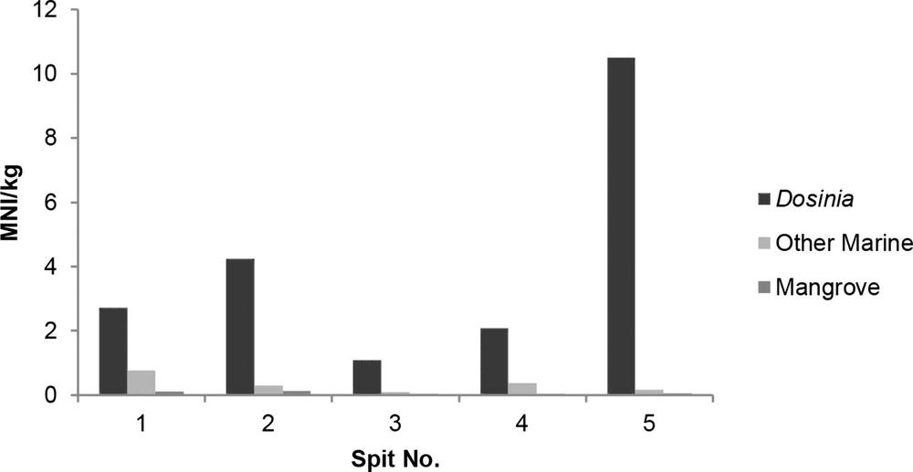
Figure 3.18 Lorrkon a-jirrapa West 1978 Shellfish by habitat (MNI/kg deposit).
Mu-garnbal 1973
The site of Mu-garnbal lies on the east side of An-gartcha Wana, about 5 km from the coast at the juncture of the mangroves and the black soil plain (Map 3.1).
Mu-garnbal is owned by the Martay. Betty describes the site and its environment:
The Matai [Martay] own no coastal sites. Their country is situated on the eastern bank of An-gartcha Wana and up to about 12 km from the coast in the mangrove, black soil plain and eucalypt woodland area. At least five different riverside and inland sites were lived in, four of which I was able to visit. Maganbal is within a few metres, and on the eastern side, of an extensive area of mangroves growing on the eastern bank of the Blyth River, its main advantage being that during the full blast of the barra (northwest monsoon) it is in the lee of this formidable barrier. The camp itself was erected on a dense midden 35 m2 in area and up to 1 m thick. The posts of the houses had been dug into the shells; the debris of 1973 [cyclone] formed only the top layer of a deposit extending back into prehistory. Black soil plains, inundated during the wet season, surround the site on all but the western side, where mud flats and mangroves clothe the riverbank (Meehan 1982a, 30).
During the 1972–73 wet season the Matai camped for a time at Maganbal on a small shell midden mound about 25 m by 10 m in area and 0.6 m thick situated on the boundary between a black soil plain and a bank of mangroves backing onto the Blyth River (Meehan 1982a, 167).
The site is named after a canoe as described in Rhys’ field notes:
In the mid-morning Moganbal [the canoe] came in with the high tide and moored. In it were David B, Mary M and Laurie M and Jimmy. They had come to pick up the rest of their gear. They are now camped on top of a gun-apila [mound] at or near Maganbal, close to the forest. They have some houses made from gangula [Arafura palm] fronds. They have been making datcho [cake] from the cycad trees in the woods. Also, they had been hunting jin-gombula [mouse] and jarrka [goanna] in the hollows and swamps of the kapal [black soil plains]. The camp at Maganbal consists of… 5 men, 4 women and 5 kids = 14 (RJ 1973, FN Bk 14, 73).
Sampling
Betty and Rhys recorded Mu-garnbal and took a sample from its low dense midden on 27–29 June 1973 (Meehan 1975, Appendix 4, p. A33).
Chronology
A Tegillarca granosa sample (Wk-17746) was dated to 3,724–3,345 cal BP (Table 3.1).
Results
The sample from Mu-garnbal is dominated by Tegillarca, a marine species, with some mangrove species (Table 3.16).
| Marine | ||||
|---|---|---|---|---|
| Tegillarca | Dosinia | Mactra | Total | |
| NISP | 304 | 1 | 1 | 306 |
| MNI | 152 | 1 | 1 | 154 |
| Wt (g) | 1083.7 | 1.1 | 21.8 | 1106.6 |
| Mangrove | |||||
|---|---|---|---|---|---|
| Terebralia | Telescopium | Nerita | Cassidula | Total | |
| NISP | 21 | 10 | 2 | 1 | 34 |
| MNI | 21 | 10 | 2 | 1 | 34 |
| Wt (g) | 67.3 | 176 | 4.6 | 1.1 | 249 |
Table 3.16 Mu-garnbal Bags 1 & 2 Shellfish taxa NISP, MNI & Wt (g) XU.
Muyu a-jirrapa Coastal Shell Midden 1974, 1978
Site description
Muyu a-jirrapa lies on the west bank of An-gartcha Wana, 1 km from its mouth and c. 1 km north of Gupanga. There is a linear midden 500 m long (Figure 3.19), with a shell mound behind (Figure 3.20). The midden was stratified on top of a sand dune and covered by jungle thicket in some parts. The edge of the midden was being eroded by the river. It was recorded by Betty and Rhys in 1974 and excavated in 1978 (Figures 3.21 and 3.22). It was still used occasionally as a camping and cooking site in 1973–74.
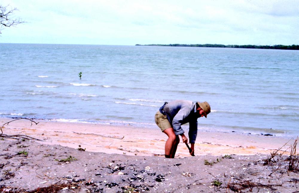
Figure 3.19 Rhys Jones at the Muyu a-jirrapa Coastal Shell Midden (Betty Meehan).
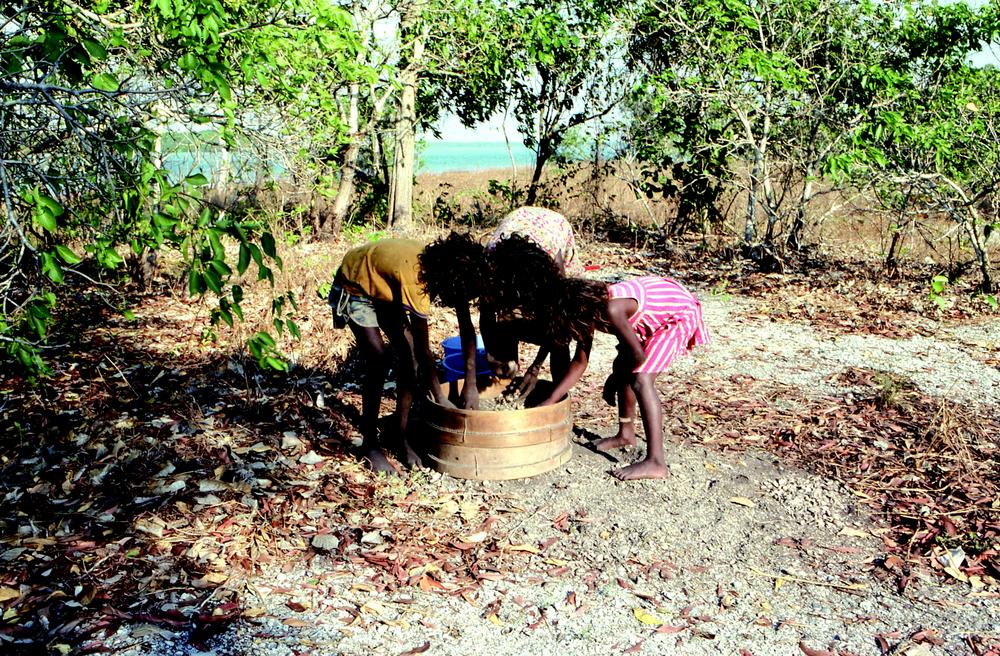
Figure 3.20 An-barra children sorting finds at Muyu a-jirrapa Shell Mound (Betty Meehan).
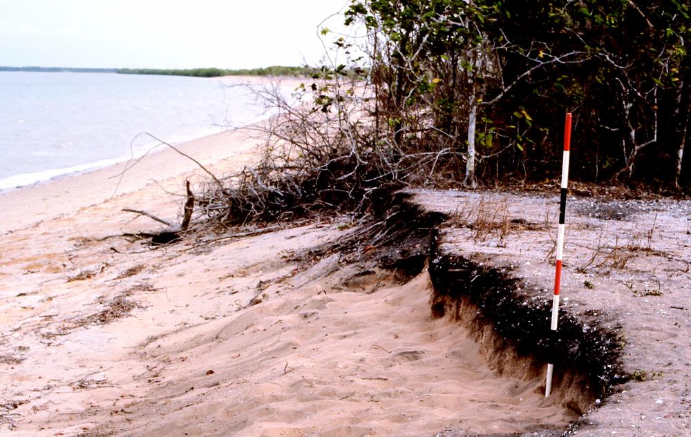
Figure 3.21 Muyu a-jirrapa Coastal Shell Midden 1978 survey (Betty Meehan).

Figure 3.22 An-barra children at Muyu a-jirrapa Coastal Shell Midden 1978 excavation (Betty Meehan).
The site was described by both Betty and Rhys:
About 4.30 pm we went to [do] some work on the eroding dune (coastal midden) at Miadjirripa. It is about 12" thick and comes almost to the present-day surface. Right on top of this midden there was a “recent” hearth with crab, fish and angalidjauwurigia [Tegillarca] remains visible in it. We also noticed a gungapila [mound] inland and to the south of this site; it was shell covered and a small, jungle-type vegetation and fruit trees were growing upon it (BM 1974, FN Bk 1, 90) (Figure 3.19).
Very high seas actually reach the base of the cutting, but usually, a beach of some 4 m separates it from most high tides (RJ 1974, FN Bk 1, 84).
In depth, the midden ranged from 23 cm to 30 cm… about 1 metre above the normal high water mark. My exposed section was 7 metres long. However, the total length of the dense midden is 75 metres along the wave cut beach berm edge – and it extends in from the berm edge distances variously: 8 metres, 12 metres, 15 metres, 4 metres. The midden is called Miadjirripa Coast 1974 (RJ 1974, FN Bk 1, 83–4) (Figure 3.20).
The top of the midden formed the top of the “dune”, and here, on the berm edge, immediately above where we took the sample was a modern… hearth 1 × 1½ metres – with remains of crab and fish… There was also another cooking hearth, about 6 m in from the berm and 2 m south of the 1st hearth… Several small jungle patches – on the midden (RJ 1974, FN Bk 1, 85).
By 1979, the midden was mostly destroyed: “The sea had eroded it [with] two large scallops into the beach/midden edge – last Barra [wet season] – no doubt held up by uprooted trees – will go next Barra” (RJ 1979, FN Bk 1, 26).
Sampling 1974
The shell midden was sampled for dating in 1974:
In the late afternoon, Betty and I went to get shell samples and C14 from a large shell midden, whose edge can be seen eroding on the beach berm about 400 yds north of the present Kopanga camp – I cleaned up the section. The midden was dense – lots of burnt shell – mostly anderabula [Dosinia] with a few diama [Marcia] plus djinagorongora [Mactra], the odd mussel and small andjelobaikuda [Syrinx]. The deposit itself was very black and blackened fringes showed that there was a lot of finely comminuted charcoal in it. However actual specks of charcoal are very rare (RJ 1974, FN Bk 1, 83).
Rhys took three solid samples and one small extra carbon sample from a depth of 20–25 cm (RJ 1974, FN Bk 1, 84).
Survey and excavation 1978
The site was surveyed and excavated in 1978 (BM 1978, FN Bk 5, 45–6) (Figure 3.22). The excavation is described by Betty in her field notes (BM 1978, FN Bk 5, 55–73):
A one metre square was laid out and excavated in six spits. The deposit was sieved through 2 mm mesh (BM 1978 FN, Bk 5, 55).
Spit 1 (0–6 cm)
This spit consists of black sand and not very many shells. Some mussels (from surface hearth above?). Lots of rootlet penetration (BM 1978, FN Bk 5, 56–7).
Spit 2 (6–16.5 cm)
Shells are becoming more numerous. There are some fish bones in this spit. Dense midden deposit in eastern half of square (BM 1978, FN Bk 5, 57–8).
Spit 3 (16.5–25 cm)
The deposit is crammed with shells, whole valves, and burnt and broken pieces. There [is] not much charcoal but some small fish bones (BM 1978, FN Bk 5, 58–61).
Spit 4 (25–35 cm)
Shells are whole and broken into small pieces… The matrix is becoming less compacted and solid, and more loose and sandy… At the end of spit 4, we are approaching clean sand (BM 1978, FN Bk 5, 63–5).
Spit 5 (35–44 cm)
The matrix is now much lighter i.e., moving into yellow sand. Many fewer shells (BM 1978, FN Bk 5, 65–6).
Spit 6
Shells are much scarcer in this spit. There is a lot of rootlet penetration… (BM 1978, FN Bk 5, 67–8).
Chronology
A date of 1,392–987 cal BP (ANU-2014) was obtained from the 1974 Dosinia sample (Table 3.1).
Results
Dosinia was the dominant shellfish, both by MNI and weight, with some mangrove species (Tables 3.17 and 3.18, Figure 3.23).
| Marine | ||||||||||
|---|---|---|---|---|---|---|---|---|---|---|
| Spit | Dosinia | Marcia | Nassarius | Mactra | Modiolus | Tegillarca | Tellina | Placamen | Volegalea | Total MNI |
| 1 | 48 | 0 | 1 | 6 | 6 | 2 | 5 | 0 | 0 | 68 |
| 2 | 56 | 10 | 0 | 1 | 4 | 2 | 0 | 0 | 0 | 73 |
| 3 | 67 | 1 | 0 | 6 | 1 | 0 | 2 | 0 | 0 | 77 |
| 4 | 226 | 14 | 4 | 2 | 1 | 1 | 0 | 3 | 1 | 252 |
| 5 | 185 | 11 | 9 | 11 | 3 | 7 | 3 | 4 | 1 | 234 |
| 6 | 27 | 19 | 18 | 3 | 5 | 1 | 3 | 1 | 1 | 78 |
| Total MNI | 609 | 55 | 32 | 29 | 20 | 13 | 13 | 8 | 3 | |
| Mangrove | ||||||||
|---|---|---|---|---|---|---|---|---|
| Cerithidea | Telescopium | Geloina | Cassidula | Crassostrea | Nerita | Terebralia | Total MNI | |
| Spit | 0 | 1 | 1 | 1 | 0 | 0 | 0 | 3 |
| 1 | 0 | 1 | 1 | 0 | 1 | 0 | 0 | 3 |
| 2 | 0 | 2 | 1 | 0 | 1 | 2 | 1 | 7 |
| 3 | 4 | 1 | 0 | 0 | 0 | 0 | 0 | 5 |
| 4 | 13 | 1 | 0 | 0 | 0 | 0 | 0 | 14 |
| 5 | 11 | 0 | 0 | 1 | 0 | 0 | 0 | 12 |
| 6 | 28 | 6 | 3 | 2 | 2 | 2 | 1 | |
Table 3.17 Muyu a-jirrapa Coastal Shell Midden 1978 Distribution of shellfish taxa (MNI).
| Marine | ||||||||||
|---|---|---|---|---|---|---|---|---|---|---|
| Spit | Dosinia | Marcia | Mactra | Tegillarca | Tellina | Modiolus | Placamen | Nassarius | Volegalea | Total Wt (g) |
| 1 | 102.2 | 0 | 25.1 | 1.3 | 14.4 | 1.7 | 0 | 0.3 | 0 | 145 |
| 2 | 114.7 | 45.5 | 4.1 | 7.3 | 0 | 4.9 | 0 | 0 | 0 | 176.5 |
| 3 | 128.7 | 6.3 | 12.8 | 0 | 3.2 | 0.2 | 0 | 0 | 0 | 151.2 |
| 4 | 583.3 | 49.9 | 5.4 | 1.9 | 0 | 1.2 | 3.5 | 2.7 | 2.7 | 650.6 |
| 5 | 487.5 | 21 | 12.5 | 16.6 | 1.7 | 3.4 | 5.9 | 2.3 | 2 | 552.9 |
| 6 | 18.2 | 9.6 | 1.4 | 1.1 | 3.7 | 7.4 | 2.4 | 6.1 | 0.5 | 50.4 |
| Total Wt (g) | 1434.6 | 132.3 | 61.3 | 28.2 | 23 | 18.8 | 11.8 | 11.4 | 5.2 | |
| Mangrove | ||||||||
|---|---|---|---|---|---|---|---|---|
| Spit | Telescopium | Crassostrea | Cerithidea | Geloina | Cassidula | Nerita | Terebralia | Total Wt (g) |
| 1 | 0.1 | 0 | 0 | 5.1 | 0.3 | 0 | 0 | 5.5 |
| 2 | 0.7 | 14.7 | 0 | 0.6 | 0 | 0 | 0 | 16 |
| 3 | 10 | 0.7 | 0 | 1.6 | 0 | 2.3 | 0.6 | 15.2 |
| 4 | 2.5 | 0 | 1.8 | 0 | 0 | 0 | 0 | 4.3 |
| 5 | 3.3 | 0 | 3.8 | 0 | 0 | 0 | 0 | 7.1 |
| 6 | 0 | 0 | 2.4 | 0 | 2.3 | 0 | 0 | 4.7 |
| Total Wt (g) | 16.6 | 15.4 | 8 | 7.3 | 2.6 | 2.3 | 0.6 | |
Table 3.18 Muyu a-jirrapa Coastal Shell Midden 1978 Distribution of shellfish taxa Wt (g).
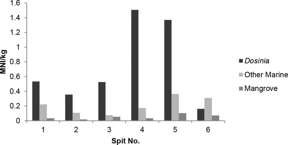
Figure 3.23 Muyu a-jirrapa Coastal Shell Midden 1978 Shellfish by habitat (MNI/kg).
Muyu-a-jirrapa Shell Mound 1974, 1978
Site description
Muyu a-jirrapa Shell Mound is small with a dense deposit of shell, located on the western bank of An-gartcha Wana about 2 km from its mouth. Rhys described the site:
In the late afternoon we went to Meadjiripa and looked at the shell mound on the dune (RJ 1974, FN Bk 1, 88–9).
[It has] a diameter of 25 m; total height – 70 cm… its east edge about 30 m from the beach – covered with light jungle – a midden scatter all the way to the beach in front. This mound was 75 m north of the north edge of the coastal berm midden exposure – “Miadjiripa 1 – beach” – samples taken a few days ago; 40 m, S/SW of the tree at the berm edge, at which FG/Nancy, Betty M etc. had cooked barramundi in 1973 (RJ 1974, FN Bk 1, 90).
Sampling 1974
I dug a 30 cm square hole in the top of the mound – really shelly… and black matrix. Dug down to 60 cm and took two solid samples from these – called “Miadjirripa 2 Mound 1974”. Here the deposit was shelly and light grey – perhaps leached of humic content… (RJ 1974, FN Bk 1, 90) (Figure 3.24).
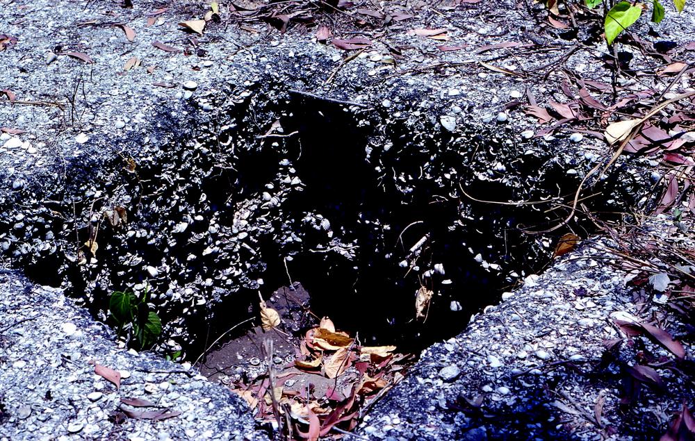
Figure 3.24 Muyu a-jirrapa Shell Mound 1974 sampling (Rhys Jones).
Note, there is another shell midden lateral deposit exposed in the beach berm close to the present camp – it is probably connected to the Anangara midden – extends along berm – a distance of some 70 metres – not as thick as the “Miadjiripa Beach berm 1” midden. On the KP dune, there are lots of midden scatters – mostly shells nowadays found – diama [Marcia], djinagoronggora [Mactra], a few ngaliwinya [Placuna], and sporadic angaldjerka [Saccostrea] oysters (RJ 1974, FN Bk 1, 91).
Excavation 1978
Muyu a-jirrapa Shell Mound was excavated by Betty in 1978 in a metre square (BM 1978, FN Bk 5, 81–2, 88–99). The excavation reached a depth of 80 cm in eight spits onto clean sand.
Chronology
Rhys speculated on the date: “It is quite possible that this mound is older than the other Kopanga middens tested” (RJ 1974, FN Bk 1, 90). And, indeed, he was correct. A Dosinia juvenilis sample taken from the lowest level of the 1978 excavation yielded a date of 1,356–867 cal BP (ANU-2816) (Table 3.1).
Results
Unfortunately, this assemblage was lost in the Canberra bushfires of 2003 when ANU’s Weston store was burnt to the ground and was never analysed. However, we do have Betty’s notes from the excavation that give some idea of the contents of the shell mound. Shells included:
- Ana-mula an-ika [Terebralia]
- An-bambula [Geloina]
- An-demburela [Tellina]
- An-dirrbula [Dosinia]
- An-guljuraba [Saccostrea]
- An-jalabaykarda [Melongenidae]
- Diyama [Marcia]
- Ngandipurdurda [Tegillarca]
- Nornda [Telescopium]
- Ana-jirralanggula [Cymbiola]
Some shells were very small, especially an-dirrbula. Rhys’ observation from his 1974 sample is that the mound contained “mostly small Anderabula” (RJ 1974, FN Bk 1, 90).
Ngarli ji-bama 1974
Site description
Ngarli ji-bama is a home base on an inland dune associated with fossil shell beds. It is located 4 km east of An-gartcha Wana, and about 1 km from the coast, and is occupied in the dry season (Figure 2.1; Maps 2.2 and 3.1). It has a good supply of water from wells surrounding the site. Although it lies close to the sea, the main shell beds (Modiolus micropterus [now modulaides]) lie 3 km away (Meehan 1982a, 31, 66–7). It is a large open site with a series of shallow midden deposits strung around the circumference. They contain burnt clay, hearth material and shells.
Ngalidjibama, a Djowanga moiety site, is situated about 6.5 km east of the Blyth River and 1 km from the coast. The camp site lies where the inland sand dune complex with its alternating parallel dunes and swales meets the eucalypt woodland. This woodland has a boundary zone consisting of several edible fruit trees – for example Sterculia quadrifolia, Pandanus and Terminalia carpentariae – and its understory is dominated by the important food plant Cycas media. The camp occupies a largely treeless area 300 m by 100 m on the crest of a dune but is surrounded by dense jungle thickets which include trees such as the banyan (Ficus virens) in the shade of which grow a tangle of yams (Dioscorea) and other vines. A low rocky ridge, encompassing Lawuk-adjirripa (stone-spear-point-place), the only stone quarry in Gidjingali country, skirts its western edge and continues south into the forest… Ample evidence for past human occupation is visible on the camp site surface… A string of freshwater holes, excavated up to 1.5 m into shelly deposits, surround the site (Meehan 1982a, 26–7).
There were lots of chunks of stone visible around Ngalidjibama. One had very distinct traces of red ochre still on it (BM 1974, FN Bk 3, 82).
Sampling
“Rhys went off to have a look at some old sites (and, hopefully to take some shell samples)” (BM 1974, FN Bk 3, 2). In 1974, a solid sample was taken from a midden by a banyan tree, one of a series of shallow midden deposits from the large open site. It was sieved through 1.5 mm mesh.
Chronology
A Mactra abbreviata sample was dated to 286–0 cal BP (Wk-17747) (Table 3.1).
Results
The sample was dominated by Mactra abbreviata (Mytilidae, a marine species) (Table 3.19).
| Marine | |||||||||
|---|---|---|---|---|---|---|---|---|---|
| Mactra | Dosinia | Nassarius | Saccostrea | Tegillarca | Cymbiola | Volegalea | Modiolus | Total | |
| NISP | 1482 | 29 | 8 | 7 | 2 | 1 | 1 | 1 | 1531 |
| MNI | 741 | 15 | 8 | 4 | 2 | 1 | 1 | 1 | 773 |
| Wt (g) | 501.1 | 44.8 | 8.5 | 34.5 | 24.5 | 5.3 | 4.8 | 1.4 | 624.9 |
| Mangrove | |||||
|---|---|---|---|---|---|
| Telescopium | Geloina | Terebralia | Nerita | Total | |
| NISP | 3 | 2 | 2 | 1 | 8 |
| MNI | 3 | 2 | 2 | 1 | 8 |
| Wt (g) | 113.7 | 4.5 | 2.4 | 1.3 | 121.9 |
Table 3.19 Ngarli ji-bama Shellfish taxa NISP, MNI & Wt (g).
Yuluk a-jirrapa Mounds 1974
Yuluk a-jirrapa contains an impressive series of shell mounds, 1 km inland, adjacent to the home base of Ngarli ji-bama, on the eastern side of An-gartcha Wana (Map 3.1). The An-barra say they were formed by the large stingray Yuluk, who made these mounds as he flapped his way along the dune (Meehan 1982a, 167–8). The mound that was sampled was 24 m in diameter and 1.5 m high.
Sampling
Rhys took a sample at a depth of 10–15 cm.
Chronology
A Dosinia juvenilis/charcoal pair (ANU-2023) was dated to 636–165 and 240–23 cal BP respectively (Table 3.1).
Results
The dominant shellfish at Yuluk a-jirrapa was Coecella horsfieldii, a marine bivalve species found in intertidal coarse sand (Table 3.20; Meehan 1982a, 168).
| Coecella horsfieldii | Dosinia | Mytilidae (various) | Mactra | Other | |
| % MNI | 83 | 10 | 3 | 1.5 | 3 |
Table 3.20 Yuluk a-jirrapa Shellfish taxa (% MNI).