1
Introduction
The information presented in this volume tells us something about how long and in what way the An-barra have occupied their current estate – rich and productive land draped around the mouth of An-gartcha Wana (Blyth River – literally Big River) in central Arnhem Land, Australia (Map 1.1).
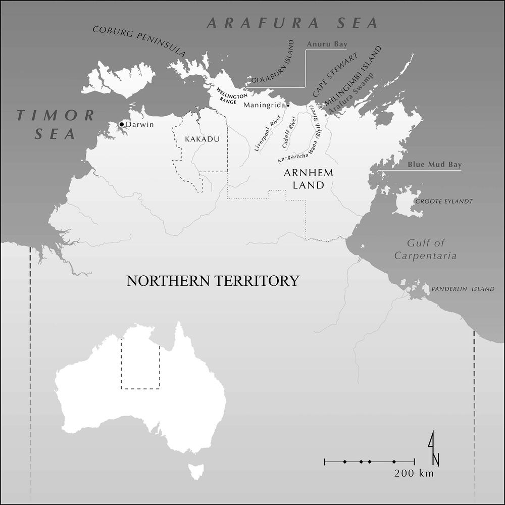
Map 1.1 Study area location map (Adam Black).
Limitations
Before we begin the An-barra story, it is important to note some shortcomings or gaps in our data. For example, the archaeological surveys have not recorded all the sites on the An-barra estate, and we certainly did not obtain radiocarbon dates for all the sites located. Also, some sites belonging to the An-barra, their ancestors or other unknown people may have been destroyed or covered by the rising and falling sea levels well-documented for this dynamic coastline. Furthermore, we do not even know for certain that An-barra ancestors occupied the sites from which our oldest dates have been obtained. However, given the vast antiquity now recorded for Aboriginal occupation of this continent (see Clarkson et al. 2017), the occupants of current An-barra land in the past may well have been An-barra ancestors or Aboriginal people of different ancestry.
An-barra occupation
How long have the An-barra occupied their current estate? No matter what the definitive answer is to this and other related questions, it is clear from the radiocarbon dates and the nature of current An-barra culture that they and possibly their ancestors have lived on their current estate for a very long time. The oldest date we have documented so far from any archaeological site is c. 3,500 years. As already stated, there is no way of knowing for certain just how long the An-barra themselves have lived on the land at the mouth of An-gartcha Wana. No human remains were found (or sought) during fieldwork. In any case, past An-barra funerary practices of secondary burial would mean that it is unlikely that human remains would be found in the archaeological record (McKenzie 1980). Nowadays, people are buried in graves at Maningrida or at various places on An-barra land – for example, Ji-bena. The complexity of contemporary An-barra culture has been recorded by many scholars over past decades – for example, see Glasgow (1994), Hamilton (1981), Hiatt (1965), Jones (1980), McKenzie (1980) and Meehan (1982a) (for a complete bibliography, see Appendix 1). Hiatt (1965) described An-barra social life in great detail. This body of research indicates a well-developed and complex culture deeply embedded in the land on which it thrived. Meehan and Jones provide insight into the way the An-barra exploit their resource-rich environment to eat well and live healthy lives. An-barra people possess detailed knowledge and understanding of the environment in which they live – the coming and going of the seasons including the danger that some seasons (for example, the wet season) may jeopardise their lives – and, of course, the availability of the animals and plants that contribute to their rich and varied diet, and the items of material culture they need to survive (Meehan 1982a).
Their territory is peppered with a great number of named places, many of which also have religious significance attached to them. Religious beliefs and practices are deeply embedded in the land on which the An-barra live and suggests that this has been the case for a very long time. The complex art associated with their religious life (both public and secret) is, unfortunately, mostly ephemeral, so leaves little evidence, if any, in the archaeological record – for example, several great song series, such as Djambitj and Goyulan (Gurrmanamana et al. 2002).
The detailed elements of contemporary An-barra life suggest that it is unlikely they are newcomers to the particular piece of land they currently own, occupy, harvest and pay religious reverence to. The complexity of their lives observed by various scholars who have lived with them over decades indicates they and probably their ancestors have been living here for a very long time – possibly far longer than the dates obtained from occupation sites so far indicate.
Historic contacts
It is known that the An-barra (or other people who may have occupied their current estate) have probably had contact with various non-Aboriginal people since the seventeenth to eighteenth centuries – Macassans from what is now the Indonesian archipelago; Europeans before 1940; and, finally, more Europeans after the establishment of Maningrida Government Settlement in 1957. Discussion, including references, concerning these contacts can be found in publications by both Hiatt (1965, 5–13) and Meehan (1982a, 16–21). For recent studies on Macassan contact in Arnhem Land, see Clark and May (2013), Wesley et al. (2016) and Xu (2021).
Macassans
It is estimated that Macassans began visiting the Arnhem Land coast from the seventeenth to eighteenth centuries (MacKnight 1976; Urwin et al. 2023; Wesley et al. 2016). They came to collect trepang (burnapi in Gu-jingarliya) for Chinese merchants in Makassar (provincial capital of present-day South Sulawesi). The Macassans worked mainly in northeast Arnhem Land where rich beds of trepang existed. However, there is some evidence to indicate that the An-barra probably had some contact with them during that time.
Hiatt has this to say:
Old Gidjingali men remember them, but I gather from their accounts that the fishermen did not come regularly to the Blyth River. There is no evidence of Indonesian ancestry among present-day Gidjingali or of changes in social life attributed to Indonesian influences. Yet at some stage several cultural changes occurred. Gidjingali now make canoes from tree trunks instead of bark and smoke long Indonesian-style pipes; they use a representation of an Indonesian mast in one of their ceremonies and refer to the visitors in songs; and the vocabulary includes perhaps a dozen words of Indonesian origin. As these innovations are widespread in Arnhem Land, it is possible that the Gidjingali adopted them from neighbours who had closer contact with the voyagers (1965, 6).
Brady (2013) discusses the introduction of arrack and tobacco to Aboriginal people in Arnhem Land by Macassans well before the First Fleet arrived in Sydney. Mitchell (1996) argues that Macassan introduction of iron and dugout canoes on the Coburg Peninsula in western Arnhem Land enabled the hunting of large marine animals, such as sea turtle and dugong.
The An-barra home base called Gupanga may well be named after Kupang (formerly Koepang), the provincial capital of the present-day eastern Indonesian province of Nusa Tenggara Timor. Frank Gurrmanamana, always anxious to educate Betty Meehan, drew her attention to a fruit tree, Tamarindus indica (called jambang by the An-barra), which he said had been brought by Macassar visitors, and a waterhole at Jinawunya, which he described as “from that Man-gajerra” (Meehan 1982a, 16–17).
Australian trepang fishers
In the second half of the nineteenth century, Australian trepang fishers entered the Arnhem Land coast but had difficulty obtaining cheap labour. Apparently, the local people preferred to work for the Indonesians (Hiatt 1965, 5–13; Meehan 1982a, 16–21).
Japanese pearl fishers
Japanese pearl fishing in the Arafura Sea began not long after the Indonesian trepang fishing ceased after 1906 due to an Australian government ban. The Japanese, in general, were not welcomed by the An-barra, though several Gunavidji (also referrednto as Ndjebbana) people worked on luggers, and two Gu-jingarliya people have Japanese ancestry. Japanese pearl fishing ceased during World War II but began again in 1953 (Gillett 1981; Meehan 1982a, 17–18; Oliver 2006).
Haultain (1971) reported that the Japanese frequently visited the coastal areas of Gu-jingarliya territory – flouting Australian law – and had entered the Blyth River at least four times to replenish water supplies (e.g. Northern Standard 1938).
Europeans before 1940
The Liverpool River was recorded by the surveyor Captain Philip Parker King in 1818 and the Blyth River by the navigator Francis Cadell in 1867. Over the next 40 years, several other people made some contact with the area, including prospector Edward Robinson (1875), explorer David Lindsay and surveyor Walter Cuthbertson (1883), explorer and surveyor Captain Carrington (1885), customs collector Alfred Searcy (1885), and Government Medical Officer Cecil Strangman (1908). In later times, crocodile hunters and pearl fishers visited the area between the Liverpool and Blyth Rivers (Hiatt 1965; Meehan 1982a, 17).
The Methodist Overseas Mission established outposts at Goulburn Island in 1916 and at Milingimbi in 1925 respectively (Hiatt 1965, 7). Apparently, Blyth River people visited Milingimbi to buy items from the trade store, but because they “were not on very good terms with the local people they usually left soon after”. The Reverend T.T. Webb, stationed at Milingimbi prior to World War II, commented:
One of the least known parts of Arnhem Land country is that along the Blyth River, which enters the sea in the southeast corner of Boucaut Bay about 30 miles from Milingimbi… The natives from this area are quite different stock from the majority of our station people… (Grant 1995; Meehan 1982a, 17).
In 1936–37, the anthropologist Donald Thomson visited Cape Stewart, at the request of the Australian government, to report on the conditions on the reserve (Meehan 1982a, 17; Peterson 2003). In 1939, mission employee Gordon Sweeney made a survey of the coast between the Blyth River and slightly west of the Liverpool River and found that “the ceremonial life and tribal authorities of groups between the two rivers were still intact”. His report contains information about the settlement patterns, diet and ceremonial life of the people from that region prior to permanent European settlement. It also included a recommendation that people from the Goulburn Island Mission visit this area regularly to set up medical and “evangelical” bases (Sweeney 1939).
Europeans after 1940
World War II intervened, and the implementation of Sweeney’s plans was delayed for 20 years. This delay may well have enabled Aboriginal people from this area (including the An-barra) to maintain their traditional culture until the present day and to return to their estate with confidence in the late 1960s. In 1955, Sweeney, then employed by the Welfare Branch, carried out a census in the Liverpool–Blyth River region. He contacted many Gu-jingarliya people who were camped at several sites where Betty and Rhys resided during 1972–73 (Hiatt 1965, 8–13; Meehan 1982a, 18–21).
The formal part of the settlement of Maningrida was set up by 1957 with the arrival of welfare workers David and Ingrid Drysdale and with the help of two patrol officers, Trevor Milikins and Ted Egan. Les Hiatt and Betty Meehan arrived on Curly Bell’s boat in 1958. By 1970, Maningrida was the fifth-largest town in the NT (Meehan 1982a, 18–19).
Outstation movement
When the Woodward Commission recommended Aboriginal land rights in 1972, many Aboriginal groups began reoccupying their traditional homelands. This recommendation was not the only reason but was part of a general phenomenon in northern Australia at the time resulting from disenchantment with low living standards, overcrowding, friction between different language groups, and the resultant violence and symptoms of social breakdown. The An-barra were no exception, and they moved back to their land around the mouth of An-gartcha Wana (Meehan 1982a, 19–21; Meehan & Jones 1980). It was here that Betty and Rhys lived with them on and off throughout the 1970s.
Regional archaeological investigations
Prior to the commencement of the An-barra Archaeological Project in 1972–73, only a few studies had been undertaken in central Arnhem Land. Nearby at Milingimbi, 35 km east of the mouth of An-gartcha Wana, earth mounds, shell mounds and middens dating to the late Holocene have been recorded (Brockwell et al. 2009, 2011; McCarthy & Setzler 1960; Mulvaney 1975; Roberts 1994). Further east, Peterson (1973) recorded earth mounds around the Arafura Swamp. Brandl (1988) recorded rock art in shelters on the nearby Cadell River to the west.
In eastern Arnhem Land, shell middens and mounds, rock art and rock shelter sites and Macassan sites have been recorded at Blue Mud Bay (Faulkner 2013), on Groote Eylandt (Clarke & Frederick 2006; Frederick & Clarke 2011) and on Vanderlin Island (Oertle et al. 2014; Sim & Wallis 2008).
In western Arnhem Land, rock art and rock shelter sites, some dating back to the Pleistocene, have been recorded in the Wellington Range (May et al. 2010; Wesley et al. 2018; Wright et al. 2023) and the Arnhem Land escarpment (David et al. 2017), and shell middens and Macassan sites have been recorded on the Coburg Peninsula and Anuru Bay (Mitchell 1996; Wesley et al. 2016). In Kakadu, many Pleistocene and Holocene sites have been investigated, including rock shelters, rock art sites, shell mounds and middens, earth mounds and artefact concentrations, as well as Madjedbebe rock shelter, the oldest recorded site in Australia (e.g. Brockwell et al. 2020; Chaloupka 1993; Clarkson et al. 2017; Jones 1985a; Kamminga & Allen 1973; May et al. 2015; Ó Foghlú 2017; Schrire 1982; Shine et al. 2013; Taçon & Brockwell 1995).
The An-barra Archaeological Project
The An-barra Archaeological Project (Brockwell et al. 2005; Meehan 1995) investigated archaeological sites located in the vicinity of An-gartcha Wana. Most of these sites belong to the An-barra community; a few to other communities. The An-barra and other communities are part of the “Gidjingali who were divided into 19 groups each owning a cluster of sites and the surrounding countryside” (Hiatt 1965, 14, Maps 3–4, Table 1). The land owned by these communities stretches from the western side of the Blyth River to Cape Stewart in the east, approximately 20 km of coastline (Map 1.1). In 1875, on his way to the Gulf of Carpentaria, Edward Robinson encountered some Aboriginal people at Cape Stewart – the most eastern land accessed by Gu-jingarliya speakers. Of this encounter, Robinson said that Aboriginal people at Cape Stewart frightened his prospecting party (Hiatt 1965, 9). Betty Meehan and Rhys Jones walked from Gupanga to Cape Stewart to attend a ceremony with several An-barra people in 1973.
Betty and Rhys collected archaeological assemblages from these sites during numerous research trips over 40 years between 1972 and 2015, with the support of Traditional Owners Frank Gurrmanamana (deceased), his wife, Nancy Bandeiyama (deceased), their daughter Betty Ngurrpangurrpa, and other family and community members.
Prior to October 2002, the An-barra archaeological collection was housed in the ANU storage facility at its Weston campus in Canberra. Most of it was moved to ANU’s main campus in Acton before the Canberra fire storm in January 2003, which destroyed 500 houses in the suburbs of Weston Creek, along with the ANU Weston store. Two boxes of An-barra archaeological material were lost: Muyu a-jirrapa Shell Mound; and soil samples from Ji-bena mound (Swete Kelly & Phear 2004).
Initially, ANU’s School of Archaeology and Anthropology in the College of Arts and Social Sciences provided storage facilities for the An-barra collection while the material was being sorted. In 2005, the collection was moved to the osteology laboratory in Archaeology and Natural History (ANH), School of Culture, History and Language, ANU College of Asia and the Pacific. Both departments provided office facilities for Sally Brockwell, who worked part-time on the An-barra Archaeological Project, funded by an AIATSIS grant from October 2002 until February 2004. Betty acted as honorary supervisor while Sally undertook the analysis and writing up (Brockwell et al. 2005). Both made a short field trip to Maningrida in August 2003, so Betty could renew contact with the An-barra community and Sally could meet them and see the archaeological sites in context. An additional visit associated with the project was made to Maningrida by Betty and Sally in 2015. Following completion of the analysis, the An-barra collection was repatriated to the Museum and Art Gallery of the Northern Territory (MAGNT) in Darwin in 2018.
Aim
The aim of the An-barra Archaeological Project (Brockwell et al. 2005; Meehan 1995) was to determine the nature of regional pre-colonial settlement patterns and subsistence strategies in central Arnhem Land against the backdrop of dramatic environmental change that took place on the coastal plains of northern Australia in the mid to late Holocene. The archaeological data was also compared with the ethnographic data presented in Betty’s book Shell Bed to Shell Midden (Meehan 1982a), noting similarities and differences and seeking explanations. This current monograph details the results of the investigations and argues that the ethnographic data are relevant for interpretation of archaeological sites belonging to the recent past.
The An-barra archaeological sites consist of earth mounds, shell mounds, linear shell middens and transect material, containing shell, other faunal remains and a small amount of stone. See Chapter 2 for definitions of these different types of sites. Occupation dates from at least 3,500 years ago, but most of the sites are less than 1,000 years old (see Chronology in Chapter 2). This reflects late Holocene sedimentary infill and progradation of the coastal plains and the recent nature of their occupation (see below). The initial results of the An-barra Archaeological Project were compared with those of other studies in the Northern Territory to develop a model of regional use of the northern coastal plains in the late Holocene (see Brockwell et al. 2005, 2009, 2011, 2013).
During her time living and working with the An-barra, Betty made a distinction between “dead men” sites and “Dreaming” sites (1982a, 166–8; see also Brockwell 2013). “Dead men” sites are those that the An-barra recognise as being made and used by their ancestors, such as shell middens. “Dreaming” sites are those they believe were created by supernatural beings in the Dreamtime, such as the large shell mounds. As Betty went on to say, “the fascinating problems raised by these data point to a logical direction for subsequent research… Only an archaeological study of the Blyth River region can ultimately place the year I spent among the Anbarra in its proper context” (Meehan 1982a, 168). This theme is explored in this monograph.
Significance
The An-barra archaeological collection is the only one of its kind from coastal central Arnhem Land. It documents the settlement patterns and economic strategies of the An-barra people of An-gartcha Wana over the last 3,500 years. It shows how the An-barra occupied new sites in their territory as the coast prograded to the north in the late Holocene. Comparisons between ethnographic shell-fishing strategies (Meehan 1982a) and the contents of the middens demonstrate change over time most likely associated with climate and environmental change. Some aspects of the archaeological analysis have been published previously (see Bourke et al. 2007; Brockwell 2013; Brockwell et al. 2005, 2009, 2011, 2013; Meehan 1982a). However, this monograph contains the results of a more complete analysis. The archaeological collection is companion to the An-gartcha Wana ethnographic collection donated to MAGNT by Betty in 2005. Together these collections offer potential for further study and insights into the ethnography and archaeology of an Aboriginal community in central Arnhem Land in the late Holocene.